IMAGES TAKEN NEAR TO
Woodburn Drive, BOLTON, BL1 6NH
Introduction
This page details the photographs taken nearby to Woodburn Drive, BL1 6NH by members of the Geograph project.
The Geograph project started in 2005 with the aim of publishing, organising and preserving representative images for every square kilometre of Great Britain, Ireland and the Isle of Man.

There are currently over 7.5m images from over14,400 individuals and you can help contribute to the project by visiting https://www.geograph.org.uk
Image Map (Loading...)


Getting Data...Please wait
Leaflet Map data © OpenStreetMap
Images are licensed for reuse under creativecommons.org/licenses/by-sa/2.0
Notes
- Clicking on the map will re-center to the selected point.
- The higher the marker number, the further away the image location is from the centre of the postcode.
Image Listing (9 Images Found)
Images are licensed for reuse under creativecommons.org/licenses/by-sa/2.0
Image
Details
Distance
1
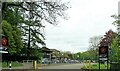
Entrance to Smithills School
On Smithills Dean Road.
Image: © philandju
Taken: 5 May 2022
0.09 miles
2
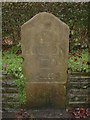
Old Milestone by Smithills Dean Road, Smithills
Carved stone post by the UC road, in parish of BOLTON (BOLTON District), Smithills Dean Road, by No. 93 - about ¼ mile North from the A58 Ring Road, Moss Bank Way, by the road, on West side of road. Bolton stone, erected by the Sharples & Hoghton turnpike trust in the 20th century. Apparently re-faced in 1983.
Inscription reads:-
{lens}
TO
BOLTON
2
MILES
CDP
1983
Carved benchmark on front mid right.
Milestone Society National ID: LA_BOSM02
Image: © Mike Faherty
Taken: 13 Jan 2011
0.11 miles
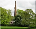
3
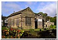
Smithills Hall
A view across the lawn towards the old hall
Image: © David Tomlinson
Taken: Unknown
0.20 miles
4
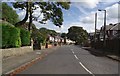
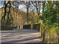
Forest Road
Near Moss Bank Park, the road runs between Barrow Bridge Road and Moss Bank Way.
Image: © philandju
Taken: 26 Sep 2011
0.21 miles
6
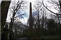
Barrow Bridge chimney
This view will be obscured by foliage within a couple of months. The chimney served a bleach works, now demolished, which stood off nearby Smithills Croft Road.
Image: © philandju
Taken: 15 Feb 2013
0.25 miles
7
Barrow Bridge chimney
A grade II listed structure that once served a now demolished bleaching factory.
Image: © philandju
Taken: 5 May 2022
0.25 miles
8
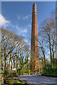
Barrow Bridge Chimney
The landmark octagonal, brick-built chimney which is all that survives from the former Halliwell Bleach Works. The chimney is dated 1863 and is one of the tallest (at 260 foot) remaining chimneys in Bolton. It is Grade II-listed (List Entry Number: 1387893 http://www.heritagegateway.org.uk/Gateway/Results_Single.aspx?uid=1387893&resourceID=5 Heritage Gateway).
Image: © David Dixon
Taken: 16 Mar 2016
0.25 miles
9

Barrow Bridge Chimney
The grade II listed structure was built in 1863 at Ainsworth's bleachworks. Originally 306 feet tall, the chimney height is now reduced to 246 feet for safety reasons. The vegetation growing from the brickwork suggests that, again for reasons of safety, the chimney is in need of some maintenance.
Image: © philandju
Taken: 1 Aug 2021
0.25 miles