IMAGES TAKEN NEAR TO
Thompson Road, BOLTON, BL1 6BU
Introduction
This page details the photographs taken nearby to Thompson Road, BL1 6BU by members of the Geograph project.
The Geograph project started in 2005 with the aim of publishing, organising and preserving representative images for every square kilometre of Great Britain, Ireland and the Isle of Man.

There are currently over 7.5m images from over14,400 individuals and you can help contribute to the project by visiting https://www.geograph.org.uk
Image Map
Images are licensed for reuse under creativecommons.org/licenses/by-sa/2.0
Notes
- Clicking on the map will re-center to the selected point.
- The higher the marker number, the further away the image location is from the centre of the postcode.
Image Listing (16 Images Found)
Images are licensed for reuse under creativecommons.org/licenses/by-sa/2.0
Image
Details
Distance
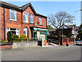
1
Smithills and Heaton Conservative Club on Chorley Old Road
Image: © Raymond Knapman
Taken: 26 Jul 2012
0.06 miles
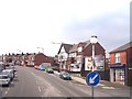
2
Smithills and Heaton Conservative Club
On Chorley Old Road (B6226).
Image: © JThomas
Taken: 28 Mar 2015
0.06 miles
4
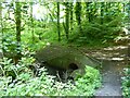
Culvert in Captain's Clough
A culvert to take the stream under Captain's Clough Road
Image: © Kevin Waterhouse
Taken: 20 Jun 2024
0.13 miles
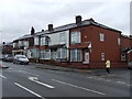
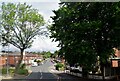
6
Bute Street, Bolton
Typical Victoria workers' houses in Bolton. I am sure this is what Tony Warren had in mind when thinking up Coronation Street some 60 years ago. Its real-life counterpart is still to be found in the 21st century.
Image: © Chris Allen
Taken: 4 Mar 2012
0.21 miles
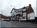
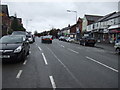
7
Ivy Road in Bolton
At its junction with Chorley Old Road.
Image: © philandju
Taken: 26 Jun 2017
0.21 miles
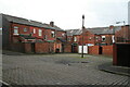
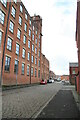
8
Atlas Nos 8 & 6 Mills, Bolton
On the right is Atlas No. 8 Mill. Built in 1866 as Shipton Mill and initially occupied by James Whittaker and Son. Became Atlas No. 8 Mills, part of the Musgrave empire, by sometime after 1900. By the 1930s it was in use by an engineering company and is now apartments. No. 6 Mill and its large projecting engine house is across the road crossing the bottom of the street.
Image: © Chris Allen
Taken: 4 Mar 2012
0.22 miles
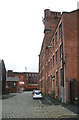
9
Bute Street and Atlas No. 8 Mill, Bolton
On the left is Atlas No. 8 Mill. Built in 1866 as Shipton Mill and initially occupied by James Whittaker and Son. Became Atlas No. 8 Mills, part of the Musgrave empire, by sometime after 1900. By the 1930s it was in use by an engineering company and is now apartments.
Image: © Chris Allen
Taken: 4 Mar 2012
0.22 miles