IMAGES TAKEN NEAR TO
Woodsleigh Coppice, BOLTON, BL1 5XR
Introduction
This page details the photographs taken nearby to Woodsleigh Coppice, BL1 5XR by members of the Geograph project.
The Geograph project started in 2005 with the aim of publishing, organising and preserving representative images for every square kilometre of Great Britain, Ireland and the Isle of Man.

There are currently over 7.5m images from over14,400 individuals and you can help contribute to the project by visiting https://www.geograph.org.uk
Image Map
Images are licensed for reuse under creativecommons.org/licenses/by-sa/2.0
Notes
- Clicking on the map will re-center to the selected point.
- The higher the marker number, the further away the image location is from the centre of the postcode.
Image Listing (12 Images Found)
Images are licensed for reuse under creativecommons.org/licenses/by-sa/2.0
Image
Details
Distance
2
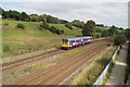
Ladybridge Lane looking towards Bolton
This is a busy section of railway on the approach to Bolton. The train is a Northern Rail Class 142 "Pacer" working the 14:52 Wigan Wallgate to Manchester Victoria service. At one time there were four parallel lines of track here. With the run down of the railway system in the 1960s and 70s the "slow" lines were removed. In the early 1990s a modern colour light signalling system was installed, centrally controlled from Manchester. This now enables a quite intensive train service to be operate on the remaining two tracks.
Image: © Ian Threlfall
Taken: 8 Sep 2007
0.12 miles
4
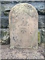
Old Boundary Marker by Lady Bridge Lane, Bolton
Parish Boundary Marker in parish of Bolton (Bolton District), bottom of Lady Bridge Lane, on footbridge over railway and River Croal, East side of lane.
Inscription reads:-
: HEATON : : DIVISION : : RUMWORTH :
Carved bench mark on centre face.
Surveyed
Milestone Society National ID: LA_HEARUM01pb
Image: © Milestone Society
Taken: Unknown
0.14 miles
5
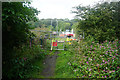
Closure of Lady Bridge Lane
The bridge over the railway has been closed due to electrification work on the line. The diversion is a long way round.
Image: © Bill Boaden
Taken: 8 Sep 2015
0.14 miles
6

Middlebrook Valley Way, Lady Bridge Lane
Combined cycle and pedestrian path and river, Middle Brook, at road bridge; the bridge continues to the left over the railway line. In 1978 the path was not named or designted as a cycle route.
Image: © M J Roscoe
Taken: Unknown
0.15 miles
7
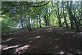
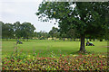
Woodland by Deane Golf Club
Viewed from one of the paths giving access round the course.
Image: © Bill Boaden
Taken: 8 Sep 2015
0.17 miles
9
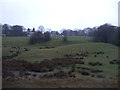
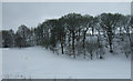
Mowers on Deane Golf Course
Keeping the fairway in trim. This is viewed over the hedge from Armadale Road.
Image: © Bill Boaden
Taken: 8 Sep 2015
0.22 miles