IMAGES TAKEN NEAR TO
Gargrave Avenue, BOLTON, BL1 5UQ
Introduction
This page details the photographs taken nearby to Gargrave Avenue, BL1 5UQ by members of the Geograph project.
The Geograph project started in 2005 with the aim of publishing, organising and preserving representative images for every square kilometre of Great Britain, Ireland and the Isle of Man.

There are currently over 7.5m images from over14,400 individuals and you can help contribute to the project by visiting https://www.geograph.org.uk
Image Map (7 Images)


Leaflet Map data © OpenStreetMap
Images are licensed for reuse under creativecommons.org/licenses/by-sa/2.0
Notes
- Clicking on the map will re-center to the selected point.
- The higher the marker number, the further away the image location is from the centre of the postcode.
Image Listing (7 Images Found)
Images are licensed for reuse under creativecommons.org/licenses/by-sa/2.0
Image
Details
Distance
1
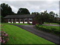
St. James the Great
R.C. church in Johnson Fold.
Image: © philandju
Taken: 18 Jul 2012
0.08 miles
2
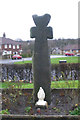
Old Wayside Cross - moved to St James the Great churchyard
Johnson Fold Cross, old head and shaft, by the off-road path, in parish of Bolton (Bolton District), St James the Great, Roman Catholic Church, Montserrat Road, Johnson Fold, was in Valletts Lane - bridge over Doffcocker Brook (now culverted), near Arkwrights Alehouse.
To be surveyed
Milestone Society National ID: MABO_BOL03
Image: © Milestone Society
Taken: Unknown
0.08 miles
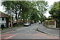
3
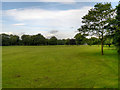
Houses on Whalley Avenue
From Hollin Hey at Johnson Fold.
Image: © philandju
Taken: 18 Jul 2012
0.10 miles
4
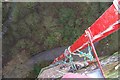
Barrow bridge chimney view
Looking down from the 260ft chimney during a 2007 inspection, last repaired by Fred Dibnah.
Image: © Tom Phillips
Taken: 2 Mar 2007
0.11 miles
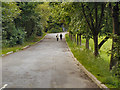
6
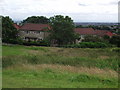
Knott Lane
A residential street off Moss Bank Way.
Image: © philandju
Taken: 28 Jun 2022
0.18 miles