IMAGES TAKEN NEAR TO
Whalley Avenue, BOLTON, BL1 5UH
Introduction
This page details the photographs taken nearby to Whalley Avenue, BL1 5UH by members of the Geograph project.
The Geograph project started in 2005 with the aim of publishing, organising and preserving representative images for every square kilometre of Great Britain, Ireland and the Isle of Man.

There are currently over 7.5m images from over14,400 individuals and you can help contribute to the project by visiting https://www.geograph.org.uk
Image Map (Loading...)


Getting Data...Please wait
Leaflet Map data © OpenStreetMap
Images are licensed for reuse under creativecommons.org/licenses/by-sa/2.0
Notes
- Clicking on the map will re-center to the selected point.
- The higher the marker number, the further away the image location is from the centre of the postcode.
Image Listing (10 Images Found)
Images are licensed for reuse under creativecommons.org/licenses/by-sa/2.0
Image
Details
Distance
1
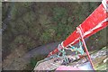
Barrow bridge chimney view
Looking down from the 260ft chimney during a 2007 inspection, last repaired by Fred Dibnah.
Image: © Tom Phillips
Taken: 2 Mar 2007
0.05 miles
2
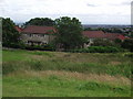
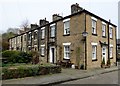
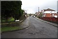
Houses on Whalley Avenue
From Hollin Hey at Johnson Fold.
Image: © philandju
Taken: 18 Jul 2012
0.13 miles
3
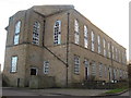
Barrowdene House, Barrow Bridge
Now converted into flats, this building is opposite the terraced housing also pictured in this square. I am not sure whether it was a factory building or a religious building but it obviously belonged to the 'model village'.
Image: © Margaret Clough
Taken: 11 Jan 2006
0.13 miles
4
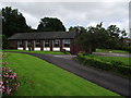
St. James the Great
R.C. church in Johnson Fold.
Image: © philandju
Taken: 18 Jul 2012
0.19 miles
5
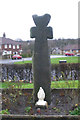
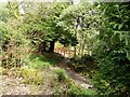
Old Wayside Cross - moved to St James the Great churchyard
Johnson Fold Cross, old head and shaft, by the off-road path, in parish of Bolton (Bolton District), St James the Great, Roman Catholic Church, Montserrat Road, Johnson Fold, was in Valletts Lane - bridge over Doffcocker Brook (now culverted), near Arkwrights Alehouse.
To be surveyed
Milestone Society National ID: MABO_BOL03
Image: © Milestone Society
Taken: Unknown
0.21 miles
6
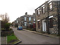
Second Street, Barrow Bridge
Barrow Bridge, on the outskirts of Bolton, was formerly a cotton manufacturing village, and these cottages were mill workers houses. The terraces, off Bazley Street, were not very imaginatively named First, Second, Third, Fourth and Fifth Streets.
Image: © philandju
Taken: 11 Apr 2016
0.21 miles
7
Terraced houses at Barrow Bridge
These were houses built for the workers at the Dean Mills cotton mills at Barrow Bridge. By 1846 the 1000 workers had good houses, some with gardens, a canteen, baker, library, co-operative shop, and educational institute. It was a 'model village' and in 1851 was visited by Prince Albert.
Image: © Margaret Clough
Taken: 11 Jan 2006
0.22 miles
9
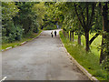
Louvaine Avenue, Barrow Bridge
A hard winter has broken the road surface in parts.
Image: © philandju
Taken: 15 Feb 2013
0.25 miles
10
The Rock Garden in Moss Bank Park
Voluntary group, The Friends of Moss Bank Park, are doing sterling work in renovating the Rock Garden which had lain untended, overgrown and closed to the public for some time.
Image: © philandju
Taken: 11 Apr 2016
0.25 miles