IMAGES TAKEN NEAR TO
Marld Crescent, BOLTON, BL1 5TH
Introduction
This page details the photographs taken nearby to Marld Crescent, BL1 5TH by members of the Geograph project.
The Geograph project started in 2005 with the aim of publishing, organising and preserving representative images for every square kilometre of Great Britain, Ireland and the Isle of Man.

There are currently over 7.5m images from over14,400 individuals and you can help contribute to the project by visiting https://www.geograph.org.uk
Image Map
Images are licensed for reuse under creativecommons.org/licenses/by-sa/2.0
Notes
- Clicking on the map will re-center to the selected point.
- The higher the marker number, the further away the image location is from the centre of the postcode.
Image Listing (36 Images Found)
Images are licensed for reuse under creativecommons.org/licenses/by-sa/2.0
Image
Details
Distance
1
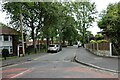
Knott Lane
A residential street off Moss Bank Way.
Image: © philandju
Taken: 28 Jun 2022
0.07 miles
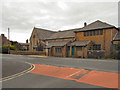
2
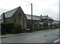
Delph Hill Methodist Church
Former church on New Church Road, now used for community functions. http://homepages.tesco.net/~anthony_lee/Churches/delph_hill.htm
Image: © Mike Faherty
Taken: 13 Jan 2011
0.13 miles
3
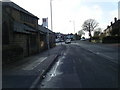
New Church Road approaching Chorley Old Road
Image: © Colin Pyle
Taken: 1 Feb 2011
0.13 miles
4
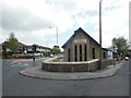
The Triangle Methodist Church
On Chorley Old Road, Bolton.
Image: © Ian S
Taken: 23 May 2015
0.13 miles
6
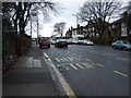
Bus stop on Chorley Old Road (B6226)
Heading west.
Image: © JThomas
Taken: 28 Mar 2015
0.14 miles
7
Delph Hill Methodist Church, Bolton
Image: © Alexander P Kapp
Taken: 28 Jan 2008
0.15 miles
8
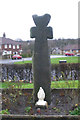
Old Wayside Cross - moved to St James the Great churchyard
Johnson Fold Cross, old head and shaft, by the off-road path, in parish of Bolton (Bolton District), St James the Great, Roman Catholic Church, Montserrat Road, Johnson Fold, was in Valletts Lane - bridge over Doffcocker Brook (now culverted), near Arkwrights Alehouse.
To be surveyed
Milestone Society National ID: MABO_BOL03
Image: © Milestone Society
Taken: Unknown
0.18 miles
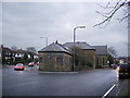
9
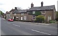
Stone cottages on Chorley Old Road
The taller house to the left was built in 1785 as a toll house for the Doffcocker Turnpike Road.
Image: © philandju
Taken: 16 May 2013
0.18 miles
10
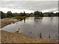
Doffcocker Lodge
Doffcocker Lodge is a former mill lodge created in 1874. It is now a Local Nature Reserve for wildfowl (http://www.lancswt.org.uk/index.php/doffcokor-lodge-and-nob-end-lnr-s.php The Wildlife Trust).
Image: © David Dixon
Taken: 13 Aug 2011
0.19 miles