IMAGES TAKEN NEAR TO
The Keep, BOLTON, BL1 5NG
Introduction
This page details the photographs taken nearby to The Keep, BL1 5NG by members of the Geograph project.
The Geograph project started in 2005 with the aim of publishing, organising and preserving representative images for every square kilometre of Great Britain, Ireland and the Isle of Man.

There are currently over 7.5m images from over14,400 individuals and you can help contribute to the project by visiting https://www.geograph.org.uk
Image Map
Images are licensed for reuse under creativecommons.org/licenses/by-sa/2.0
Notes
- Clicking on the map will re-center to the selected point.
- The higher the marker number, the further away the image location is from the centre of the postcode.
Image Listing (12 Images Found)
Images are licensed for reuse under creativecommons.org/licenses/by-sa/2.0
Image
Details
Distance
4
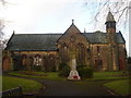
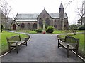
Christ Church Heaton
Near Markland Hill, Bolton
Image: © Richard Cooke
Taken: 7 Dec 2013
0.10 miles
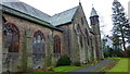
5
Christ Church, Heaton
Church of England parish church.
Image: © philandju
Taken: 30 Jan 2014
0.10 miles

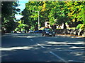
8
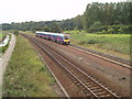
Ladybridge Lane looking towards Lostock
The channel of Middle Brook runs alongside the railway alignment for several miles between Lostock Junction and the district of Gilnow. Between Middle Brook and the railway is a popular public footpath. On the extreme left of the picture (in a southerly direction) are the fairways of Deane Golf Course. To the right (north) is a very upmarket residential area. The train is a TransPennine Express Class 185, almost new at the time of the picture, working the 13:35 Windermere to Manchester Airport.
Image: © Ian Threlfall
Taken: 8 Sep 2007
0.22 miles
9
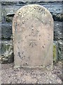
Old Boundary Marker by Lady Bridge Lane, Bolton
Parish Boundary Marker in parish of Bolton (Bolton District), bottom of Lady Bridge Lane, on footbridge over railway and River Croal, East side of lane.
Inscription reads:-
: HEATON : : DIVISION : : RUMWORTH :
Carved bench mark on centre face.
Surveyed
Milestone Society National ID: LA_HEARUM01pb
Image: © Milestone Society
Taken: Unknown
0.22 miles
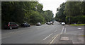
10
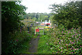
Closure of Lady Bridge Lane
The bridge over the railway has been closed due to electrification work on the line. The diversion is a long way round.
Image: © Bill Boaden
Taken: 8 Sep 2015
0.23 miles