IMAGES TAKEN NEAR TO
Handley Gardens, BOLTON, BL1 5GR
Introduction
This page details the photographs taken nearby to Handley Gardens, BL1 5GR by members of the Geograph project.
The Geograph project started in 2005 with the aim of publishing, organising and preserving representative images for every square kilometre of Great Britain, Ireland and the Isle of Man.

There are currently over 7.5m images from over14,400 individuals and you can help contribute to the project by visiting https://www.geograph.org.uk
Image Map
Images are licensed for reuse under creativecommons.org/licenses/by-sa/2.0
Notes
- Clicking on the map will re-center to the selected point.
- The higher the marker number, the further away the image location is from the centre of the postcode.
Image Listing (13 Images Found)
Images are licensed for reuse under creativecommons.org/licenses/by-sa/2.0
Image
Details
Distance
1
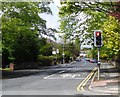
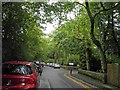
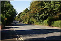
Albert Road, Bolton
A quiet residential road off Chorley New Road.
Image: © Bill Boaden
Taken: 22 Sep 2012
0.12 miles
3
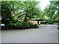
The Chapel at Overdale West Crematorium
Image: © Alexander P Kapp
Taken: 18 Jul 2007
0.14 miles
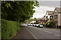
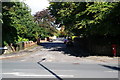
4
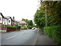
Chorley New Road, Bolton
A wide leafy road which looks much the same as this for over 2 kilometres.
Image: © Bill Boaden
Taken: 22 Sep 2012
0.16 miles
7
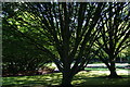
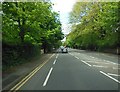
The Garden of Remembrance, Overdale Cemetery
Viewed from Overdale Drive.
Image: © Bill Boaden
Taken: 22 Sep 2012
0.21 miles