IMAGES TAKEN NEAR TO
Chorley New Road, BOLTON, BL1 5AZ
Introduction
This page details the photographs taken nearby to Chorley New Road, BL1 5AZ by members of the Geograph project.
The Geograph project started in 2005 with the aim of publishing, organising and preserving representative images for every square kilometre of Great Britain, Ireland and the Isle of Man.

There are currently over 7.5m images from over14,400 individuals and you can help contribute to the project by visiting https://www.geograph.org.uk
Image Map (Loading...)


Getting Data...Please wait
Leaflet Map data © OpenStreetMap
Images are licensed for reuse under creativecommons.org/licenses/by-sa/2.0
Notes
- Clicking on the map will re-center to the selected point.
- The higher the marker number, the further away the image location is from the centre of the postcode.
Image Listing (6 Images Found)
Images are licensed for reuse under creativecommons.org/licenses/by-sa/2.0
Image
Details
Distance
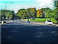
1
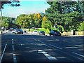
Chorley New Road/Beaumont Road Junction
The junction of Chorley New Road (A673) with Bolton's outer ring road, the A58 (Victoria Road to the right; Beaumont Road to the left).
Image: © David Dixon
Taken: 25 Sep 2010
0.13 miles
2
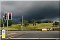
Junction of Beaumont Road and Chorley New Road
Under a threatening sky.
Image: © philandju
Taken: 21 Jul 2020
0.15 miles
3
Chorley New Road (A673)
Crossing Beaumont Road on the left.
Image: © David Dixon
Taken: 25 Sep 2010
0.18 miles