IMAGES TAKEN NEAR TO
Marshdale Road, BOLTON, BL1 5AQ
Introduction
This page details the photographs taken nearby to Marshdale Road, BL1 5AQ by members of the Geograph project.
The Geograph project started in 2005 with the aim of publishing, organising and preserving representative images for every square kilometre of Great Britain, Ireland and the Isle of Man.

There are currently over 7.5m images from over14,400 individuals and you can help contribute to the project by visiting https://www.geograph.org.uk
Image Map (Loading...)


Getting Data...Please wait
Leaflet Map data © OpenStreetMap
Images are licensed for reuse under creativecommons.org/licenses/by-sa/2.0
Notes
- Clicking on the map will re-center to the selected point.
- The higher the marker number, the further away the image location is from the centre of the postcode.
Image Listing (7 Images Found)
Images are licensed for reuse under creativecommons.org/licenses/by-sa/2.0
Image
Details
Distance
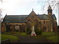
1
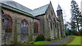
Christ Church Heaton
Near Markland Hill, Bolton
Image: © Richard Cooke
Taken: 7 Dec 2013
0.18 miles
2
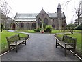
Christ Church, Heaton
Church of England parish church.
Image: © philandju
Taken: 30 Jan 2014
0.18 miles