IMAGES TAKEN NEAR TO
Carslake Avenue, BOLTON, BL1 4BP
Introduction
This page details the photographs taken nearby to Carslake Avenue, BL1 4BP by members of the Geograph project.
The Geograph project started in 2005 with the aim of publishing, organising and preserving representative images for every square kilometre of Great Britain, Ireland and the Isle of Man.

There are currently over 7.5m images from over14,400 individuals and you can help contribute to the project by visiting https://www.geograph.org.uk
Image Map
Images are licensed for reuse under creativecommons.org/licenses/by-sa/2.0
Notes
- Clicking on the map will re-center to the selected point.
- The higher the marker number, the further away the image location is from the centre of the postcode.
Image Listing (31 Images Found)
Images are licensed for reuse under creativecommons.org/licenses/by-sa/2.0
Image
Details
Distance

3
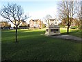
Cenotaph, Queen's Park
Remembering the dead in the two world wars of the 5th Battalion, Loyal North Lancashire Regiment.
Image: © philandju
Taken: 29 Dec 2013
0.16 miles
4
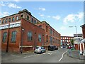
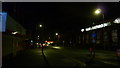
Gower Street
Dominated by Columbia Mills on the left
Image: © Kevin Waterhouse
Taken: 20 Jun 2024
0.16 miles
5
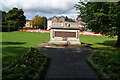
War memorial of the 5th Battalion The Loyal North Lancashire Regiment
In the north west corner of Queens Park, with Chorley New Road visible behind. The striking thing is the length of the list of names from one battalion who died in the First World War. I am reliably informed that there are 1,012 names, though haven't counted them myself.
Image: © Bill Boaden
Taken: 22 Sep 2012
0.16 miles

8
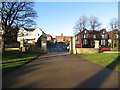
Queen's Park entrance
Looking towards Chorley New Road.
Image: © philandju
Taken: 29 Dec 2013
0.18 miles
9
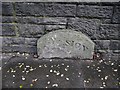
Old Boundary Marker by the A673, Chorley New Road, Bolton Parish
Parish Boundary Marker by the A673, in parish of Bolton (Bolton District), Chorley New Road, 10m West of junction with Kirkhall Lane, against wall, North side of road.
Surveyed
Milestone Society National ID: LA_HALLBO02pb
Image: © Philip Platt
Taken: 1 Dec 2011
0.18 miles
10
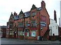
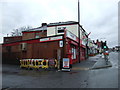
The Victory, Bolton
Public house on Chorley Old Road (B6226).
Image: © JThomas
Taken: 28 Mar 2015
0.19 miles