IMAGES TAKEN NEAR TO
Royal Court Drive, BOLTON, BL1 4AZ
Introduction
This page details the photographs taken nearby to Royal Court Drive, BL1 4AZ by members of the Geograph project.
The Geograph project started in 2005 with the aim of publishing, organising and preserving representative images for every square kilometre of Great Britain, Ireland and the Isle of Man.

There are currently over 7.5m images from over14,400 individuals and you can help contribute to the project by visiting https://www.geograph.org.uk
Image Map (Loading...)


Getting Data...Please wait
Leaflet Map data © OpenStreetMap
Images are licensed for reuse under creativecommons.org/licenses/by-sa/2.0
Notes
- Clicking on the map will re-center to the selected point.
- The higher the marker number, the further away the image location is from the centre of the postcode.
Image Listing (42 Images Found)
Images are licensed for reuse under creativecommons.org/licenses/by-sa/2.0
Image
Details
Distance
1
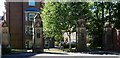
Gate piers at a former hospital entrance
The gates were off Chorley New Road at the entrance to the now demolished Bolton Royal Infirmary. The hospital opened in 1914 as the Bolton Dispensary and closed circa 1999. Although the gate piers remain the central and left side gates have been replaced by fixed railings with only a right side gate remaining for emergency access to the housing and grounds behind.
Image: © philandju
Taken: 22 Jun 2018
0.04 miles
2
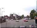
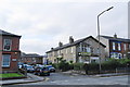
Chorley New Road joins Chorley Old Road at Bolton
New Road on the left, Old Road straight on
Image: © Raymond Knapman
Taken: 26 Jul 2012
0.08 miles
4

Bus stop and shelter on Chorley Old Road (B6226)
Image: © JThomas
Taken: 28 Mar 2015
0.09 miles
5
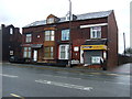
Shop and houses on Chorley Old Road (B6226)
Image: © JThomas
Taken: 28 Mar 2015
0.10 miles
6
Chayah House Clinic
Bolton Healing Rooms, a centre for alternative healing.
Image: © Bill Boaden
Taken: 15 Sep 2012
0.12 miles
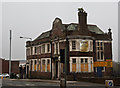
7
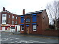
The Nelson, Bolton
Public house on Chorley Old Road (B6226).
Image: © JThomas
Taken: 28 Mar 2015
0.12 miles
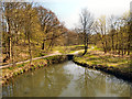
9
Dobson Bridge, Queen's Park
Dobson Bridge, crossing the lodge adjacent to the River Croal in Queen's Park.
Dobson Bridge was erected in 1878 to link the original park with a later extension to the south east, over the River Croal. The section over the river has ornamental stone piers with ornate cast iron plaques bearing the Bolton Crest. It has a parapet of latticed ironwork and is carried over the lodges adjacent to the river on cast iron columns with capitals, supporting ornamental spandrels.
Image: © David Dixon
Taken: 1 May 2013
0.14 miles
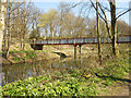
10
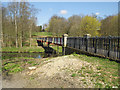
Dobson Bridge
Dobson Bridge was erected in 1878 to link the original park with a later extension to the south east, over the River Croal. The section over the river has ornamental stone piers with ornate cast iron plaques bearing the Bolton Crest. It has a parapet of latticed ironwork and is carried over the lodges adjacent to the river on cast iron columns with capitals, supporting ornamental spandrels.
Image: © David Dixon
Taken: 1 May 2013
0.15 miles