IMAGES TAKEN NEAR TO
Chorley Street, BOLTON, BL1 4AL
Introduction
This page details the photographs taken nearby to Chorley Street, BL1 4AL by members of the Geograph project.
The Geograph project started in 2005 with the aim of publishing, organising and preserving representative images for every square kilometre of Great Britain, Ireland and the Isle of Man.

There are currently over 7.5m images from over14,400 individuals and you can help contribute to the project by visiting https://www.geograph.org.uk
Image Map
Images are licensed for reuse under creativecommons.org/licenses/by-sa/2.0
Notes
- Clicking on the map will re-center to the selected point.
- The higher the marker number, the further away the image location is from the centre of the postcode.
Image Listing (46 Images Found)
Images are licensed for reuse under creativecommons.org/licenses/by-sa/2.0
Image
Details
Distance
2
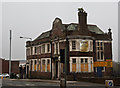
St George's Road
The A673 into Bolton. On the corner of Vernon Street is a building dated 1910. I'm not sure what it was originally but now it is the home of Melody Pop Tuition Management, although I'm uncertain if the business is still active.
Image: © Gerald England
Taken: 19 May 2018
0.06 miles
3
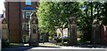
Gate piers at a former hospital entrance
The gates were off Chorley New Road at the entrance to the now demolished Bolton Royal Infirmary. The hospital opened in 1914 as the Bolton Dispensary and closed circa 1999. Although the gate piers remain the central and left side gates have been replaced by fixed railings with only a right side gate remaining for emergency access to the housing and grounds behind.
Image: © philandju
Taken: 22 Jun 2018
0.09 miles
4
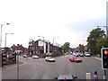
Chorley New Road joins Chorley Old Road at Bolton
New Road on the left, Old Road straight on
Image: © Raymond Knapman
Taken: 26 Jul 2012
0.11 miles
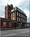
5
Former school and workshop for the blind
The building, dating from 1867, now houses a skills and employment advice centre together with other advice and social help bodies.
Image: © philandju
Taken: 17 May 2022
0.12 miles
6

Bus stop and shelter on Chorley Old Road (B6226)
Image: © JThomas
Taken: 28 Mar 2015
0.12 miles
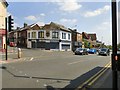
7
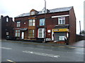
Shop and houses on Chorley Old Road (B6226)
Image: © JThomas
Taken: 28 Mar 2015
0.13 miles
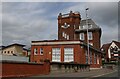
8
Offices, Marsden Road, Bolton
Original use unknown. Above the entrance is an inscription, "Established 1867", but the present building is clearly early C20th neo-Georgian, sober enough except for the rather flamboyant Baroque tower.
Currently home to BASE (Bolton Accommodation Support Employment), the National Careers Service and Connexions.
Image: © Stephen Richards
Taken: 24 Aug 2017
0.13 miles
9
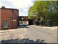
Low bridge over Bark Street
The bridge carries Marsland Road over Bark Street. It was erected in 1876 as detailed in a commemorative plaque Image on the bridge.
It has a height restriction of 3.9m / 12' 9".
Image: © Gerald England
Taken: 19 May 2018
0.14 miles
10
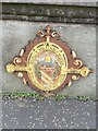
Charles Wolfenden plaque on bridge
Lord Mayor of Bolton 1875-77
Image: © Mrs W J Sutherland
Taken: 30 Jun 2024
0.14 miles