IMAGES TAKEN NEAR TO
Newton Walk, BOLTON, BL1 3UD
Introduction
This page details the photographs taken nearby to Newton Walk, BL1 3UD by members of the Geograph project.
The Geograph project started in 2005 with the aim of publishing, organising and preserving representative images for every square kilometre of Great Britain, Ireland and the Isle of Man.

There are currently over 7.5m images from over14,400 individuals and you can help contribute to the project by visiting https://www.geograph.org.uk
Image Map
Images are licensed for reuse under creativecommons.org/licenses/by-sa/2.0
Notes
- Clicking on the map will re-center to the selected point.
- The higher the marker number, the further away the image location is from the centre of the postcode.
Image Listing (13 Images Found)
Images are licensed for reuse under creativecommons.org/licenses/by-sa/2.0
Image
Details
Distance
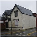
1
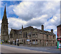
All Souls church
The school building belonging to this church is now an Islamic centre.
Image: © Margaret Clough
Taken: 9 Feb 2006
0.05 miles
2
Old Toll House by Halliwell Road, Bolton
Toll House, No. 259, Halliwell Road (A6099).
To be surveyed
Milestone Society National ID: MA.BOL02
Image: © Milestone Society
Taken: Unknown
0.12 miles
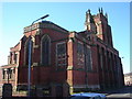
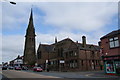
4
Former Congregation Congregational Church, Blackburn Road
The former Congregational Church on Blackburn Road, Bolton, now in secular use.
Image: © David Dixon
Taken: 13 Jul 2011
0.18 miles
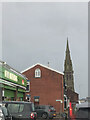
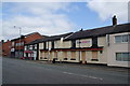
5
The Iron Church
No longer in use as a church, but occupied by a fashion business. The church still appears to use the buildings to the right.
Image: © Bill Boaden
Taken: 15 Sep 2012
0.18 miles
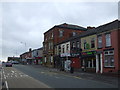
7
The Victoria British Queen
A boarded up pub. The Old Original British Queen opposite is still trading.
Image: © Bill Boaden
Taken: 15 Sep 2012
0.21 miles
8
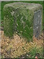
Old Boundary Marker by Boundary Street, Bolton Parish
Parish Boundary Marker by the UC road, in parish of Bolton (Bolton District), Boundary Street, Western end of street on verge, South side of road.
Surveyed
Milestone Society National ID: LA_BOL05pb
Image: © Milestone Society
Taken: Unknown
0.21 miles
9
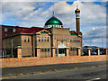
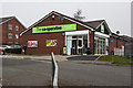
Masjid-e-Noor, "Bolton Mosque"
The Masjid (mosque) on Halliwell Road in Bolton (The entrance is actually on Prospect Street).
Image: © David Dixon
Taken: 13 Jul 2011
0.21 miles