IMAGES TAKEN NEAR TO
Battenberg Road, BOLTON, BL1 3BQ
Introduction
This page details the photographs taken nearby to Battenberg Road, BL1 3BQ by members of the Geograph project.
The Geograph project started in 2005 with the aim of publishing, organising and preserving representative images for every square kilometre of Great Britain, Ireland and the Isle of Man.

There are currently over 7.5m images from over14,400 individuals and you can help contribute to the project by visiting https://www.geograph.org.uk
Image Map (Loading...)


Getting Data...Please wait
Leaflet Map data © OpenStreetMap
Images are licensed for reuse under creativecommons.org/licenses/by-sa/2.0
Notes
- Clicking on the map will re-center to the selected point.
- The higher the marker number, the further away the image location is from the centre of the postcode.
Image Listing (27 Images Found)
Images are licensed for reuse under creativecommons.org/licenses/by-sa/2.0
Image
Details
Distance

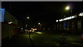
2
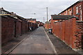
Back street in Bolton
This is wider than many, so that vehicles including bin lorries can get up it.
Image: © Bill Boaden
Taken: 15 Sep 2012
0.06 miles
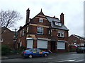
4
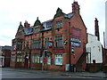
The Victory, Bolton
Public house on Chorley Old Road (B6226).
Image: © JThomas
Taken: 28 Mar 2015
0.07 miles
5
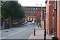
Avenue Street, Bolton
A traditional mill at the end, though with a more modern occupant.
Image: © Bill Boaden
Taken: 15 Sep 2012
0.08 miles
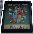
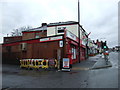
8
The Kings Arms, Bolton
On Chorley Old Road (B6226).
Image: © JThomas
Taken: 28 Mar 2015
0.11 miles
9
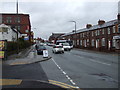
Chorley Old Road (B6226)
Heading north west.
Image: © JThomas
Taken: 28 Mar 2015
0.14 miles