IMAGES TAKEN NEAR TO
St. Georges Street, BOLTON, BL1 2DT
Introduction
This page details the photographs taken nearby to St. Georges Street, BL1 2DT by members of the Geograph project.
The Geograph project started in 2005 with the aim of publishing, organising and preserving representative images for every square kilometre of Great Britain, Ireland and the Isle of Man.

There are currently over 7.5m images from over14,400 individuals and you can help contribute to the project by visiting https://www.geograph.org.uk
Image Map
Images are licensed for reuse under creativecommons.org/licenses/by-sa/2.0
Notes
- Clicking on the map will re-center to the selected point.
- The higher the marker number, the further away the image location is from the centre of the postcode.
Image Listing (265 Images Found)
Images are licensed for reuse under creativecommons.org/licenses/by-sa/2.0
Image
Details
Distance
1
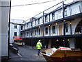
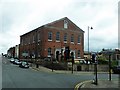
New development on St Georges Road, Bolton
The outside of an old stone building has been left, and then the guts have been ripped out to be replaced with this, twenty or so apartments.
Image: © Alexander P Kapp
Taken: 31 Jan 2008
0.02 miles
2
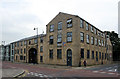
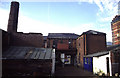
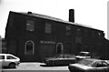
Former Hope Foundry, St George's Street
A fine example of an early 19th century factory, with the buildings surrounding an enclosed yard accessed through a gateway. It may have started life around 1800 as a textile mill, but was in use as a foundry by the late 1820s. Now sympathetically converted into flats.
Image: © Alan Murray-Rust
Taken: 25 Jul 2012
0.03 miles
3
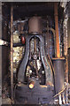
Steam engine in a cupboard.
Originally George Taylors Brassworks but was by 1995 S & S Engineering. The engine was later tidied up and connected to an electric motor but has now been moved for private preservation.
It was an inverted vertical single cylinder by Tangyes of Birmingham (Cornwall Works, Smethwick in fact).
Image: © Chris Allen
Taken: 15 Oct 1994
0.03 miles
4
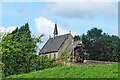
All Saints Church
Originally the church on this site was "the chapel i' th' fields". Its successor, built in 1870, is no longer "i' th' fields", but is surrounded by buildings and busy roads. The grade II listed building is now a Ukrainian Catholic church.
Image: © philandju
Taken: 3 Aug 2021
0.04 miles
5
Brassworks, All Saints Street
Was George Taylors but was by 1995 trading as S & S Engineering. Now no more. A really ramshackle works of a type that is sadly disappearing. On my first visit here the owner arranged a meeting with the late Fred Dibnah.
Image: © Chris Allen
Taken: 15 Oct 1994
0.04 miles
6
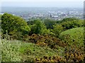
Bolton from Horrocks Wood
Bolton Town Hall and the parish church of St. Peter, Bolton le Moors are visible amid the haze.
Image: © philandju
Taken: 31 May 2015
0.05 miles
7
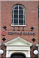
Genting Casino - Wesleyan
The casino is located in the former Wesleyan Methodist Chapel on St George's Road http://www.geograph.org.uk/photo/981407 . One wonders what John Wesley would have thought about its change of use. The building itself dates from 1803 and is Listed Grade II.
Image: © Alan Murray-Rust
Taken: 25 Jul 2012
0.07 miles
8
Casino on Higher Bridge Street
Formerly a Methodist church.
Image: © philandju
Taken: 7 Jul 2017
0.07 miles
9
George Taylor's Brass Foundry
Latterly S & S Engineering. Is home to a Tangye steam engine, derelict in a "cupboard". The owner arranged a meeting with Fred Dibnah, before he was quite so famous.
Image: © Chris Allen
Taken: 6 Jun 1983
0.07 miles
10
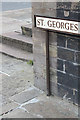
Bench mark, St George's Road
Cut into the plinth surrounding the former Methodist Church.
Image: © Alan Murray-Rust
Taken: 25 Jul 2012
0.07 miles