IMAGES TAKEN NEAR TO
Newport Street, BOLTON, BL1 1PB

Introduction

This page details the photographs taken nearby to Newport Street, BL1 1PB by members of the Geograph project.

The Geograph project started in 2005 with the aim of publishing, organising and preserving representative images for every square kilometre of Great Britain, Ireland and the Isle of Man.

There are currently over 7.5m images from over14,400 individuals and you can help contribute to the project by visiting https://www.geograph.org.uk

Image Map


Images are licensed for reuse under creativecommons.org/licenses/by-sa/2.0
Notes
  • Clicking on the map will re-center to the selected point.
  • The higher the marker number, the further away the image location is from the centre of the postcode.

Image Listing (411 Images Found)

Images are licensed for reuse under creativecommons.org/licenses/by-sa/2.0
  • ...
Image
Details
Distance
1
Newport Street
Viewed from Great Moor Street
Image: © David Dixon Taken: 14 Feb 2010
0.01 miles
2
Demolition Work on Newport Street
Buildings along Newport Street are being demolished to make way for the new £48million Bolton Interchange. Work began in mid-December as the old shop units are being knocked down so the new bus station can be built. The interchange project has been developed by a partnership between Transport for Greater Manchester (TfGM) and Bolton Council. When finished, the new bus station will be linked to the train station in Trinity Street with an enclosed footbridge. http://goo.gl/ptcBsG Bolton News
Image: © David Dixon Taken: 3 Jan 2014
0.02 miles
3
Newport Street towards the bridge
Looking along Newport Street towards the bridge and Trinity Church in the distance.
Image: © Bill Nicholls Taken: 15 Jul 2010
0.02 miles
4
Bridge on Newport St
This bridge was strengthened by adding the arched frame and cables. Under the bridge is the railway line to Preston. Framed by the arch is the tower of Trinity Church
Image: © Dave Whalley Taken: 5 Apr 2006
0.03 miles
5
Bolton - Old & New
In the foreground is the cobbled "Section Street" leading down to Newport Street and the Millennium Bridge.
Image: © John Tustin Taken: 3 Aug 2009
0.03 miles
6
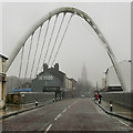
Bolton Arch, Newport Street
The outline of the town hall is just visible through the mist and gloom, looking through the arch on Newport Street. The steel parabolic arch, which acts as a gateway to the town centre for those arriving at the nearby Trinity Street Railway Station, is actually the support for the railway bridge. The old bridge was closed in 2001 as it was judged to be too weak to carrying the amount of traffic using it. The new bridge opened in 2005. http://happypontist.blogspot.com/2010/04/manchester-bridges-14-newport-street.html - The Happy Pontilist's Blog
Image: © David Dixon Taken: 12 Feb 2012
0.03 miles
7
Newport Street, Bolton
At the bridge over the railway. The building in the background was Trinity C. of E. church but is now converted into apartments.
Image: © philandju Taken: 17 Apr 2022
0.03 miles
8
Bolton - former railway triangle north of Trinity Street station
The northern arm of the triangle is long gone, but the shape can just be discerned. Main line to Preston to the left, Blackburn branch to the right. The area occupied by vans is a proposed site for a new Bolton bus station.
Image: © Peter Whatley Taken: 24 Mar 2012
0.03 miles
9
Newport Street Bridge
Carrying Newport Street over the Bolton to Preston railway line.
Image: © philandju Taken: 8 Jun 2018
0.03 miles
10
Bolton Interchange
The entrance into the new bus station.
Image: © Gerald England Taken: 30 Dec 2017
0.03 miles
  • ...