IMAGES TAKEN NEAR TO
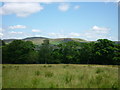
Troutbeck Drive, BURY, BL0 9YF
Introduction
This page details the photographs taken nearby to Troutbeck Drive, BL0 9YF by members of the Geograph project.
The Geograph project started in 2005 with the aim of publishing, organising and preserving representative images for every square kilometre of Great Britain, Ireland and the Isle of Man.

There are currently over 7.5m images from over14,400 individuals and you can help contribute to the project by visiting https://www.geograph.org.uk
Image Map (Loading...)


Getting Data...Please wait
Leaflet Map data © OpenStreetMap
Images are licensed for reuse under creativecommons.org/licenses/by-sa/2.0
Notes
- Clicking on the map will re-center to the selected point.
- The higher the marker number, the further away the image location is from the centre of the postcode.
Image Listing (55 Images Found)
Images are licensed for reuse under creativecommons.org/licenses/by-sa/2.0
Image
Details
Distance
1
Lower Dick Field to Shuttleworth
Taken at the top of the track leading up alongside Lower Dick Field between Stubbins and Carr, Lancashire, I am looking east towards Shuttleworth and Turf Moor.
Image: © Carroll Pierce
Taken: 15 Jul 2015
0.06 miles
2

Higher Dick Field to Harden Moor
Taken as I make my way up the path running alongside Higher Dick Field, Helmshore Road, Lancashire, I am looking across the valley to Harden Moor.
Image: © Carroll Pierce
Taken: 15 Jul 2015
0.09 miles
3
Lower Dick Field and Carr Barn Wood
Taken on the path from Ox Hey Wood, Stubbins, Lancashire, to Carr as it passes through Lower Dick Field, I am looking east across Carr Barn Wood to the Knowl Moor end of Scout Moor wind farm.
Image: © Carroll Pierce
Taken: 15 Jul 2015
0.10 miles
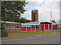
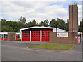
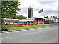
6
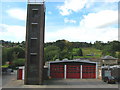
Ramsbottom Fire Station
Situated to the north of Ramsbottom on Stubbins Lane the fire station has two Volvo water ladder appliances on stand by at any one time.
Image: © Paul Anderson
Taken: 18 Sep 2007
0.13 miles
8
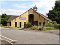
Christ Church & Neighbourhood Centre
Christ Church is a joint Baptist and Methodist church.
The present building, on a plot of land, off Great Eaves Road, was completed in November 1999. It replaces the former Baptist Church, which was situated on Bolton Street and the Market Place Methodist Church in Ramsbottom.
http://www.christchurch-ramsbottom.co.uk/History.html for more information
Image: © David Dixon
Taken: 25 Jun 2010
0.14 miles
9
Christ Church, Ramsbottom
This is a joint Baptist and Methodist Church.
Image: © Bill Boaden
Taken: 2 Jan 2010
0.14 miles