IMAGES TAKEN NEAR TO
Haworth Avenue, BURY, BL0 9UX
Introduction
This page details the photographs taken nearby to Haworth Avenue, BL0 9UX by members of the Geograph project.
The Geograph project started in 2005 with the aim of publishing, organising and preserving representative images for every square kilometre of Great Britain, Ireland and the Isle of Man.

There are currently over 7.5m images from over14,400 individuals and you can help contribute to the project by visiting https://www.geograph.org.uk
Image Map
Images are licensed for reuse under creativecommons.org/licenses/by-sa/2.0
Notes
- Clicking on the map will re-center to the selected point.
- The higher the marker number, the further away the image location is from the centre of the postcode.
Image Listing (23 Images Found)
Images are licensed for reuse under creativecommons.org/licenses/by-sa/2.0
Image
Details
Distance
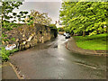
2
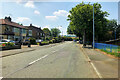
B6214 near Greenmount
The B6214 towards Holcombe Brook, at its junction with Newcombe Road towards Summerseat.
Image: © David Dixon
Taken: 2 Dec 2021
0.16 miles
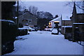
3
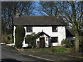
Stood The Test Of Time.
This cottage ,on Summerseat Lane near to its junction with Newcombe Road, has certainly stood the test of time.
It was built nearly 290 years ago in 1720
For an in depth history of the area click on http://web.archive.org/web/20120403223316/http://summerseat.ourwardfamily.com/about_summerseat.htm
Image: © Paul Anderson
Taken: 1 Mar 2007
0.16 miles
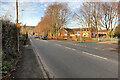
4
B6214 Longsight Lane
Looking south (towards Bury).
Image: © David Dixon
Taken: 2 Dec 2021
0.18 miles
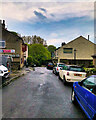
6
Hazel Hall Lane, Summerseat
There are two pubs right opposite each other. The Footballers Inn has the best beer.
Image: © Bill Boaden
Taken: 20 Dec 2009
0.18 miles
7
Higher Summerseat, Hamers Arms and Footballers Inn
The only two pubs in the village are opposite each other! Hamers Arms on the left, Footballers Inn on the left.
Image: © David Dixon
Taken: 13 May 2021
0.18 miles
8
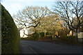
Oak Tree, Summerseat Lane
The tree was saved when the road was diverted. The original 'road' can be seen to the right of the tree which the goes behind the white house with a very sharp bend and joins up again with the modern road.
Image: © Keith Burroughs
Taken: 15 Oct 2023
0.18 miles
9
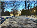
Summerseat House
Looking from Newcombe Road, across the grounds of Summerseat House.
Summerseat House was built in 1836 as a large mansion to house the mill owner, Richard Hamer.
From 1911, it came to be used as a home for sick children. http://summerseat.ourwardfamily.com/1930's_at_summerseat_house.htm has recollections by Lillian Galloway of time she spent convalescing at the house in the 1930s.
It is now used as a special school "New Summerseat House". It is a Grade II listed building.
Image: © David Dixon
Taken: 18 Dec 2011
0.18 miles
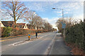
10
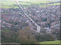
Longsight Road Holcombe Brook
The road down the centre of the picture is the B6214
Longsight Road in Holcombe Brook.
Photograph was taken from Image
Image: © Paul Anderson
Taken: 21 Mar 2008
0.19 miles