IMAGES TAKEN NEAR TO
Mayfield Road, BURY, BL0 9TB
Introduction
This page details the photographs taken nearby to Mayfield Road, BL0 9TB by members of the Geograph project.
The Geograph project started in 2005 with the aim of publishing, organising and preserving representative images for every square kilometre of Great Britain, Ireland and the Isle of Man.

There are currently over 7.5m images from over14,400 individuals and you can help contribute to the project by visiting https://www.geograph.org.uk
Image Map (Loading...)


Getting Data...Please wait
Leaflet Map data © OpenStreetMap
Images are licensed for reuse under creativecommons.org/licenses/by-sa/2.0
Notes
- Clicking on the map will re-center to the selected point.
- The higher the marker number, the further away the image location is from the centre of the postcode.
Image Listing (35 Images Found)
Images are licensed for reuse under creativecommons.org/licenses/by-sa/2.0
Image
Details
Distance
5
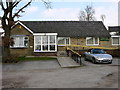
Garden City Medical Centre
GP practice in Holcombe Brook
Image: © liz dawson
Taken: 24 Mar 2007
0.10 miles
6
Holcombe Brook Tennis Club
This popular local amenity is looking for a new site locally
http://holcombebrook.totaltennis.net/home/home.asp
Image: © liz dawson
Taken: 12 Mar 2007
0.11 miles
8
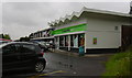
Co-op Store, Fourways, Longsight Road, Holcombe Brook
Image: © Robert Wade
Taken: 28 Jul 2009
0.12 miles