IMAGES TAKEN NEAR TO
Royal Gardens, BURY, BL0 9SB
Introduction
This page details the photographs taken nearby to Royal Gardens, BL0 9SB by members of the Geograph project.
The Geograph project started in 2005 with the aim of publishing, organising and preserving representative images for every square kilometre of Great Britain, Ireland and the Isle of Man.

There are currently over 7.5m images from over14,400 individuals and you can help contribute to the project by visiting https://www.geograph.org.uk
Image Map
Images are licensed for reuse under creativecommons.org/licenses/by-sa/2.0
Notes
- Clicking on the map will re-center to the selected point.
- The higher the marker number, the further away the image location is from the centre of the postcode.
Image Listing (70 Images Found)
Images are licensed for reuse under creativecommons.org/licenses/by-sa/2.0
Image
Details
Distance
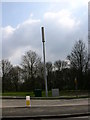
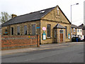
3

Bolton Road West, Holcombe Brook
The A676.
Image: © David Dixon
Taken: 24 Apr 2010
0.06 miles
5
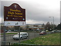
Woodhey High School
This is the Bolton Road West entrance to Woodhey High School that was built in 1979 to replace the old Ramsbottom Secondary School.
The school has been awarded £7.5M of government money which will enable it to build new facilities, enlarge classrooms, renew tired areas and refurbish most of the school. The process of planning the improvements has already started and the works are likely to continue until December 2008.
For more information about Woodhey High School click on http://www.woodhey.bury.sch.uk/
Image: © Paul Anderson
Taken: 23 Mar 2007
0.08 miles
6
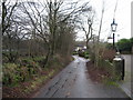
Woodhey Road Holcombe Brook
Once a shortcut through to Summerseat this lane is now a no through road.
Image: © Paul Anderson
Taken: 13 Jan 2007
0.08 miles
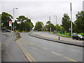
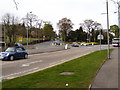
7
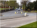
Lumb Carr Road
Lumb Carr Road (B6214), at its junction with Bolton Road West (A676), at Holcombe Brook.
Image: © David Dixon
Taken: 24 Apr 2010
0.08 miles
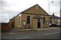
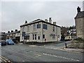
8
Holcombe Brook Methodist Church
Bolton Road West, Holcombe Brook.
Image: © David Dixon
Taken: 24 Apr 2010
0.08 miles
9
The Brook, Bolton Road West, Ramsbottom
Image: © Alexander P Kapp
Taken: 19 Jan 2010
0.09 miles
10
Bolton Road West - Lumb Carr Road Junction
The junction of Lumb Carr Road (B6214) with Bolton Road West (A676) at Holcombe Brook.
Image: © David Dixon
Taken: 24 Apr 2010
0.09 miles