IMAGES TAKEN NEAR TO
Chester Drive, BURY, BL0 9PZ
Introduction
This page details the photographs taken nearby to Chester Drive, BL0 9PZ by members of the Geograph project.
The Geograph project started in 2005 with the aim of publishing, organising and preserving representative images for every square kilometre of Great Britain, Ireland and the Isle of Man.

There are currently over 7.5m images from over14,400 individuals and you can help contribute to the project by visiting https://www.geograph.org.uk
Image Map (Loading...)


Getting Data...Please wait
Leaflet Map data © OpenStreetMap
Images are licensed for reuse under creativecommons.org/licenses/by-sa/2.0
Notes
- Clicking on the map will re-center to the selected point.
- The higher the marker number, the further away the image location is from the centre of the postcode.
Image Listing (24 Images Found)
Images are licensed for reuse under creativecommons.org/licenses/by-sa/2.0
Image
Details
Distance
1
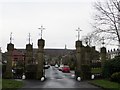
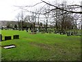
Gateway to Ramsbottom Cemetery
The tower on the hill is Peel Tower at Holcombe.
Image: © philandju
Taken: 12 Jan 2015
0.03 miles
2
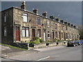
Cemetery Road Ramsbottom
These old stone houses are on Cemetery Road which is a short no through road that only leads down to the local cemetery at the bottom of the hill.
For more information about Ramsbottom click on http://web.archive.org/web/20051218151821/http://www.ramsbottom.net/history.htm
Image: © Paul Anderson
Taken: 23 Mar 2007
0.07 miles
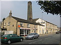
3
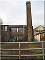
Spencer's Mill Chimney
The mill on Bolton Road West was built around 1840
http://www.jshlaser.co.uk/home.htm
Image: © David Dixon
Taken: 24 Apr 2010
0.07 miles
4
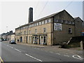
Spencers Mill
This Grade II listed mill on Bolton Road West was built around 1840 and is the home of John Spencer (Hazelhurst) Ltd http://www.jshlaser.co.uk/home.htm
See also Image
For more information about the history of Ramsbottom click on http://web.archive.org/web/20051218151821/http://www.ramsbottom.net/history.htm
Image: © Paul Anderson
Taken: 28 Mar 2007
0.08 miles
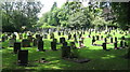
5
Ramsbottom Cemetery
Municipal cemetery serving the town of Ramsbottom.
Image: © philandju
Taken: 12 Jan 2015
0.08 miles
6
Mill and Cottages on Bolton Road West
The Grade II listed mill was built around 1840 and is the home of John Spencer (Hazelhurst) Ltd http://www.jshlaser.co.uk/history.htm
The cottages on the left that house the hair dressers etc are also Grades II listed buildings and were built around 1820
Thanks to the Ramsbottom Heritage Society for the above information.
Image
Image: © Paul Anderson
Taken: 28 Mar 2007
0.09 miles
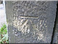
7
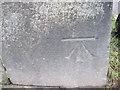
Ordnance Survey Cut Mark
This mark can be found on a wall alongside Bolton Road West in Hazelhurst.
Image: © Peter Wood
Taken: 25 Jan 2012
0.10 miles
8
Ramsbottom Cemetery
Located at the bottom of Image
is Ramsbottom Cemetery.
Image: © Paul Anderson
Taken: 24 Aug 2008
0.10 miles
9
Ordnance Survey Cut Mark
This mark can be found on the wall on Bolton Road West, Hazelhurst.
Image: © Peter Wood
Taken: 25 Jan 2012
0.12 miles
10
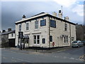
The Brook Public House
Situated on Bolton Road West almost opposite Image is The Brook public house which has just undergone major refurbishment to the exterior.
For more information about Ramsbottom click on http://web.archive.org/web/20051218151821/http://www.ramsbottom.net/history.htm
Image: © Paul Anderson
Taken: 23 Mar 2007
0.13 miles