IMAGES TAKEN NEAR TO
Beechacre, BURY, BL0 9LS
Introduction
This page details the photographs taken nearby to Beechacre, BL0 9LS by members of the Geograph project.
The Geograph project started in 2005 with the aim of publishing, organising and preserving representative images for every square kilometre of Great Britain, Ireland and the Isle of Man.

There are currently over 7.5m images from over14,400 individuals and you can help contribute to the project by visiting https://www.geograph.org.uk
Image Map (Loading...)


Getting Data...Please wait
Leaflet Map data © OpenStreetMap
Images are licensed for reuse under creativecommons.org/licenses/by-sa/2.0
Notes
- Clicking on the map will re-center to the selected point.
- The higher the marker number, the further away the image location is from the centre of the postcode.
Image Listing (73 Images Found)
Images are licensed for reuse under creativecommons.org/licenses/by-sa/2.0
Image
Details
Distance
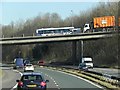
1
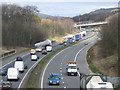
M66 Ramsbottom
Three turbine blades are seen here on the M66 at Ramsbottom enroute to the Scout Moor Wind Farm.http://www.geograph.org.uk/gallery/scout_moor_wind_farm_under_construction_6568
This 'Northern Section' of the M66 was completed and opened to traffic in May 1978.
Because of the nature of the rock in this area it was found possible to design the side slopes to a very steep angle of 4 in 1.
Blasting was required to excavate the cutting and a pre-splitting technique was specified to obtain an even appearance to the rock face.
Source The Motorway Archive http://www.iht.org/motorway/m66buryebp.htm
Image
Image: © Paul Anderson
Taken: 18 Mar 2008
0.05 miles
2

M61, looking south from Bury New Road bridge
Image: © Alexander P Kapp
Taken: 20 Jan 2010
0.06 miles
4

Ramsbottom : M66 Motorway
Heading along the M66.
Image: © Lewis Clarke
Taken: 27 Sep 2019
0.08 miles
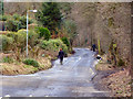
6
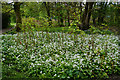
Wild garlic and Japanese knotweed
On the fringes of Nuttall Park. Both are technically invasive species, though wild garlic is considered much more acceptable, and allegedly gave Ramsbottom its name.
Image: © Bill Boaden
Taken: 6 May 2017
0.11 miles
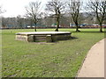
7
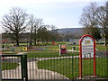
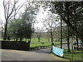
Playground - Nuttall park
This playground has been vastly improved in recent years.
The council seem to have misspelt Nuttall Park (see other pictures for this gridsquare).
Image: © liz dawson
Taken: 24 Mar 2007
0.11 miles
10
M66, Bury New Road Bridge at Ramsbottom
Image: © David Dixon
Taken: 24 Mar 2014
0.15 miles