IMAGES TAKEN NEAR TO
Nuttall Lane, BURY, BL0 9JX
Introduction
This page details the photographs taken nearby to Nuttall Lane, BL0 9JX by members of the Geograph project.
The Geograph project started in 2005 with the aim of publishing, organising and preserving representative images for every square kilometre of Great Britain, Ireland and the Isle of Man.

There are currently over 7.5m images from over14,400 individuals and you can help contribute to the project by visiting https://www.geograph.org.uk
Image Map
Images are licensed for reuse under creativecommons.org/licenses/by-sa/2.0
Notes
- Clicking on the map will re-center to the selected point.
- The higher the marker number, the further away the image location is from the centre of the postcode.
Image Listing (81 Images Found)
Images are licensed for reuse under creativecommons.org/licenses/by-sa/2.0
Image
Details
Distance
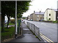
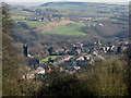
1

Nuttall Lane
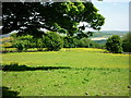
View over Ramsbottom from Holcombe towards St. Andrew's Church, Nuttall Lane and the Irwell Gorge. The area in the photograph shows a moraine left by the last Ice Age where the River Irwell has cut a deep gorge between Ramsbottom and Summerseat.
Image: © John Tomlinson
Taken: 24 Sep 2014
0.01 miles
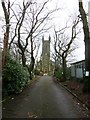
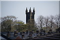
3

The tower of St Andrew's Church
As seen from the Top Field playing field.
Image: © Bill Boaden
Taken: 31 Dec 2019
0.03 miles
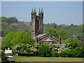
4
St. Andrew's, Ramsbottom
Church of England parish church currently closed and undergoing repair after damage from a lightning strike.
Image: © philandju
Taken: 12 Jan 2015
0.03 miles
5
From One Church to Another
This picture is taken from the grounds of Image looking south east.
To the left you can see the bell tower of Image
On the hillside beyond, running from left to right under the bridge is, Image
The farm just below in front of the motorway bridge is Image
Image: © Paul Anderson
Taken: 5 Feb 2007
0.04 miles
6
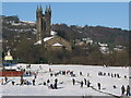
St Andrews Church Ramsbottom
With the backdrop of St Andrews Church the children from St Andrews Primary School take time out from their lessons and make the most of a recent snowfall on the schools playing fields.
Image
Image: © Paul Anderson
Taken: 3 Dec 2008
0.04 miles
7
Tagg Wood from Cross Lane
Taken on Cross Lane, Holcombe, Lancashire, just before the path connecting the walker to Lumb Carr Road (at the car park), I am looking east to Tagg Wood and across Ramsbottom to Harden Moor across the M66.
Image: © Carroll Pierce
Taken: 11 Jun 2015
0.04 miles
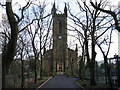
8
St Andrew's Church, Ramsbottom above the rooftops
The church tower stands out and is visible from a long way in all directions. I encountered this view by accident.
Image: © Bill Boaden
Taken: 12 Apr 2009
0.04 miles
9
St Andrews Church Ramsbottom
Built in 1834 by the Grant family St Andrews is the oldest church in Ramsbottom.
For more detailed information see Image
For more information about the history of Ramsbottom click on http://www.ramsbottomheritage.co.uk/
Image: © Paul Anderson
Taken: 3 May 2007
0.04 miles
10
St Andrews Church Ramsbottom
St Andrew’s Church was built in 1834 by the Grant family as a church in connection with the Presbyterian Church in Scotland. St Andrew’s is the oldest church in Ramsbottom and the Grant Brothers are believed to be the original Cheeryble Brothers of Dicken’s ‘Nicholas Nickleby’.
The church had a somewhat stormy existence in the 1860s until in 1869 the last member of the Grant family deprived the congregation of its church and offered it to the first Bishop of Manchester as an Anglican Church.
Eventually it became a mission church attached to St Paul’s, Ramsbottom, and then, in 1875, Bishop Fraser consecrated it as the Parish Church of St Andrew.
The building is probably unique in being the only Parish Church formerly used by another denomination.
More St Andrews church information click http://web.archive.org/web/20081006113905/http://www.retm.co.uk/content/view/19/41/
See also Image
Image: © Paul Anderson
Taken: 5 Jan 2007
0.05 miles