IMAGES TAKEN NEAR TO
Bolton Street, BURY, BL0 9JD
Introduction
This page details the photographs taken nearby to Bolton Street, BL0 9JD by members of the Geograph project.
The Geograph project started in 2005 with the aim of publishing, organising and preserving representative images for every square kilometre of Great Britain, Ireland and the Isle of Man.

There are currently over 7.5m images from over14,400 individuals and you can help contribute to the project by visiting https://www.geograph.org.uk
Image Map (Loading...)


Getting Data...Please wait
Leaflet Map data © OpenStreetMap
Images are licensed for reuse under creativecommons.org/licenses/by-sa/2.0
Notes
- Clicking on the map will re-center to the selected point.
- The higher the marker number, the further away the image location is from the centre of the postcode.
Image Listing (150 Images Found)
Images are licensed for reuse under creativecommons.org/licenses/by-sa/2.0
Image
Details
Distance
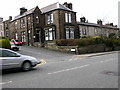
2
Samlesbury House Ramsbottom
Built in 1884 this gothic-style house, on the corner of Buchanan Street in Ramsbottom, is a Grade II listed building and was originally
a Manse (a house provided for a minister).
Image: © Paul Anderson
Taken: 29 Jul 2007
0.04 miles
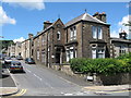
3
Stanley Street, Ramsbottom
Terraced stone cottages.
Image: © philandju
Taken: 12 Jan 2015
0.06 miles
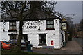
4
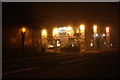
The Major on a foggy evening
One of the best local pubs.
Image: © Bill Boaden
Taken: 9 Nov 2009
0.06 miles
5
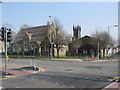
Saint Andrews Primary School
At the junction of Bolton Road West and Nuttall Lane is Saint Andrews Church of England Primary School.
The church tower in the centre of the picture is Image
Image: © Paul Anderson
Taken: 27 Mar 2007
0.07 miles
6
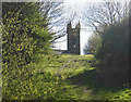
Path on Church Fields
St Andrew's Church is ahead. The fields were subject to a fairly recent village green application to prevent development by the owner, but this application failed. However subsequently the trees have been given TPO (Tree Preservation Order) protection, and this should be sufficient to keep the land undeveloped.
Image: © Bill Boaden
Taken: 19 Apr 2020
0.07 miles
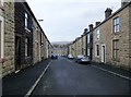
7
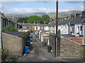
A Back Lane in Ramsbottom
This back lane in Ramsbottom serves as the rear access to properties on Major Street on the left and Stanley Street on the right.
The wind turbines in the top left of the picture
are the Scout Moor Wind Farm http://www.geograph.org.uk/gallery/scout_moor_wind_farm_under_construction_6568
Image: © Paul Anderson
Taken: 24 Sep 2008
0.07 miles
8
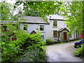
"Lodge Cottages" off Kay Brow, Ramsbottom
Image: © Robert Wade
Taken: 26 Jun 2011
0.07 miles
9

St Andrew's Church Of England Primary School, Ramsbottom
Image: © Robert Wade
Taken: 28 Jul 2009
0.07 miles
10
The Major, Ramsbottom
A pub slightly out of the town centre, but worth visiting.
Image: © Bill Boaden
Taken: 17 Feb 2009
0.07 miles