IMAGES TAKEN NEAR TO
Hazel Hall Lane, BURY, BL0 9FS
Introduction
This page details the photographs taken nearby to Hazel Hall Lane, BL0 9FS by members of the Geograph project.
The Geograph project started in 2005 with the aim of publishing, organising and preserving representative images for every square kilometre of Great Britain, Ireland and the Isle of Man.

There are currently over 7.5m images from over14,400 individuals and you can help contribute to the project by visiting https://www.geograph.org.uk
Image Map (Loading...)


Getting Data...Please wait
Leaflet Map data © OpenStreetMap
Images are licensed for reuse under creativecommons.org/licenses/by-sa/2.0
Notes
- Clicking on the map will re-center to the selected point.
- The higher the marker number, the further away the image location is from the centre of the postcode.
Image Listing (18 Images Found)
Images are licensed for reuse under creativecommons.org/licenses/by-sa/2.0
Image
Details
Distance
1
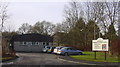
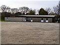
Emmanuel Church Centre - Longsight Road - Holcombe Brook - Ramsbottom - BL8 4D
Image: © Robert Wade
Taken: 31 Jan 2010
0.09 miles
2
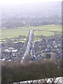
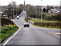
Longsight Road Holcombe Brook
Very straight road from Holcombe brook towards Bury.
Image: © liz dawson
Taken: 19 Mar 2007
0.09 miles
3
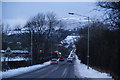
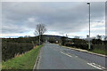
Longsight Road, Holcombe Brook
You appear to be driving straight at the hill, and at first you don't see most of the built-up area.
Image: © Bill Boaden
Taken: 20 Dec 2009
0.10 miles
4
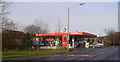
Total Petrol Station, Longsight Road, Holcombe Brook
Image: © Robert Wade
Taken: 31 Jan 2010
0.10 miles
5
Longsight Road
The view towards Holcombe Hill and the Peel Tower.
Image: © David Dixon
Taken: 25 Dec 2021
0.10 miles
6
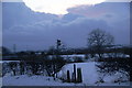
Two footpaths leave from this point
This is on Longsight Road. Both paths take you to the Kirklees valley, but the one on the right goes slightly nearer to Greenmount.
Image: © Bill Boaden
Taken: 20 Dec 2009
0.11 miles
8
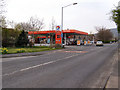
Filling Station, Longsight Road
The Total petrol station on Longsight Road (B6214)
Image: © David Dixon
Taken: 24 Apr 2010
0.15 miles
9
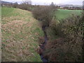
Stream under Brandlesholme Road
The stream, which is not named on OS maps, is viewed here from the B6215.
Image: © philandju
Taken: 21 Jan 2012
0.18 miles
10
Brandlesholme Road (B6215)
Looking along Brandlesholme Road towards Greenmount. The Spire of Image] can be seen at the end of the road.
Image: © David Dixon
Taken: 8 Apr 2010
0.19 miles