IMAGES TAKEN NEAR TO
Moors View, BURY, BL0 9FL
Introduction
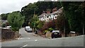
This page details the photographs taken nearby to Moors View, BL0 9FL by members of the Geograph project.
The Geograph project started in 2005 with the aim of publishing, organising and preserving representative images for every square kilometre of Great Britain, Ireland and the Isle of Man.

There are currently over 7.5m images from over14,400 individuals and you can help contribute to the project by visiting https://www.geograph.org.uk
Image Map (Loading...)


Getting Data...Please wait
Leaflet Map data © OpenStreetMap
Images are licensed for reuse under creativecommons.org/licenses/by-sa/2.0
Notes
- Clicking on the map will re-center to the selected point.
- The higher the marker number, the further away the image location is from the centre of the postcode.
Image Listing (183 Images Found)
Images are licensed for reuse under creativecommons.org/licenses/by-sa/2.0
Image
Details
Distance
1

Thelma Street, Ramsbottom
Thelma Street in Ramsbottom, Greater Manchester, England, is composed of red brick terraced houses.
Image: © Steven Haslington
Taken: 21 Jul 2013
0.05 miles
2
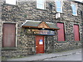
Buchanan Sports and Social Club
This social club is well used by the local community.
Image: © liz dawson
Taken: 24 Mar 2007
0.08 miles
3
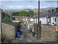
A Back Lane in Ramsbottom
This back lane in Ramsbottom serves as the rear access to properties on Major Street on the left and Stanley Street on the right.
The wind turbines in the top left of the picture
are the Scout Moor Wind Farm http://www.geograph.org.uk/gallery/scout_moor_wind_farm_under_construction_6568
Image: © Paul Anderson
Taken: 24 Sep 2008
0.10 miles
4
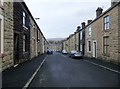
Stanley Street, Ramsbottom
Terraced stone cottages.
Image: © philandju
Taken: 12 Jan 2015
0.11 miles
5
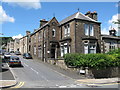
Samlesbury House Ramsbottom
Built in 1884 this gothic-style house, on the corner of Buchanan Street in Ramsbottom, is a Grade II listed building and was originally
a Manse (a house provided for a minister).
Image: © Paul Anderson
Taken: 29 Jul 2007
0.12 miles
6
Dundee Lane Ramsbottom
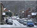
This narrow lane in Ramsbottom is hard to negotiate at the best of times what
with all the parked cars on both sides of the road but becomes a nightmare after heavy snowfall especially with the lack of any gritters who rarely venture up this lane.
Image: © Paul Anderson
Taken: 2 Dec 2008
0.12 miles
7
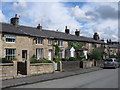
Cottages on Dundee Lane Ramsbottom
This row of cottages on Dundee Lane in Ramsbottom
were built in the mid 1800s.
Image: © Paul Anderson
Taken: 6 Jul 2008
0.13 miles
8
To Scout and Knowl Moors
Taken on Cross Lane, Holcombe, Lancashire, I am looking north east to Scout and Knowl Moors. The glare of the sun has rendered the wind farm spread out along those moors invisible on this shot.
Image: © Carroll Pierce
Taken: 11 Jun 2015
0.13 miles
9
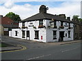
The Major Ramsbottom
Located on Bolton Street in Ramsbottom this public house has just had the outside walls repainted white and it certainly catches the eye of passers by.
Image: © Paul Anderson
Taken: 27 Jul 2007
0.13 miles
10
Dundee Lane, Ramsbottom
In the 1840s there was only Dundee House and Dundee School along this lane, which wasn't mapped as 'Dundee Lane' until 1891. There were one or two more homes by 1927, but the houses seen here were built between 1927 and 1939.
Image: © Christine Johnstone
Taken: 11 Sep 2021
0.13 miles