IMAGES TAKEN NEAR TO
Gincroft Lane, BURY, BL0 0QY
Introduction
This page details the photographs taken nearby to Gincroft Lane, BL0 0QY by members of the Geograph project.
The Geograph project started in 2005 with the aim of publishing, organising and preserving representative images for every square kilometre of Great Britain, Ireland and the Isle of Man.

There are currently over 7.5m images from over14,400 individuals and you can help contribute to the project by visiting https://www.geograph.org.uk
Image Map (Loading...)


Getting Data...Please wait
Leaflet Map data © OpenStreetMap
Images are licensed for reuse under creativecommons.org/licenses/by-sa/2.0
Notes
- Clicking on the map will re-center to the selected point.
- The higher the marker number, the further away the image location is from the centre of the postcode.
Image Listing (7 Images Found)
Images are licensed for reuse under creativecommons.org/licenses/by-sa/2.0
Image
Details
Distance
1
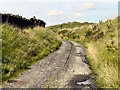
Water Board Access Road
This road has no name but was built by the water board many years ago to access the water filtration plant at New Hall and reservoir higher up the Edenfield valley.
The road runs for a distance of about a mile where it ends at Image
Image: © Paul Anderson
Taken: 2 Dec 2008
0.15 miles
3
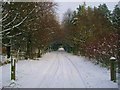
Gin Croft Lane
Looking down the hill, towards Edenfield.
Image: © David Dixon
Taken: 1 Sep 2010
0.17 miles
4
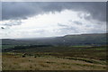
The slopes of Dearden Moor
There is a water board building on the left. The slope continues all the way down to Edenfield, and Ramsbottom beyond.
Image: © Bill Boaden
Taken: 10 Oct 2009
0.20 miles
5
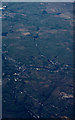
Rossendale from the air
Viewed from a Dublin bound flight from Prague. See also Image
Image: © Thomas Nugent
Taken: 3 Jun 2015
0.21 miles
6
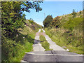
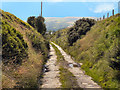
Gin Croft Lane
After passing Gin Croft Farm, the lane turns into a track.
Image: © David Dixon
Taken: 1 Sep 2010
0.22 miles
7
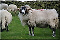
A proud ram
There were a few rams in this field, no doubt so that they could do the business. They sported some fine horns.
Image: © Bill Boaden
Taken: 10 Oct 2009
0.25 miles