IMAGES TAKEN NEAR TO
Stubbins Vale Terrace, BURY, BL0 0NN
Introduction
This page details the photographs taken nearby to Stubbins Vale Terrace, BL0 0NN by members of the Geograph project.
The Geograph project started in 2005 with the aim of publishing, organising and preserving representative images for every square kilometre of Great Britain, Ireland and the Isle of Man.

There are currently over 7.5m images from over14,400 individuals and you can help contribute to the project by visiting https://www.geograph.org.uk
Image Map (Loading...)


Getting Data...Please wait
Leaflet Map data © OpenStreetMap
Images are licensed for reuse under creativecommons.org/licenses/by-sa/2.0
Notes
- Clicking on the map will re-center to the selected point.
- The higher the marker number, the further away the image location is from the centre of the postcode.
Image Listing (108 Images Found)
Images are licensed for reuse under creativecommons.org/licenses/by-sa/2.0
Image
Details
Distance
1
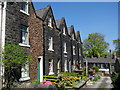
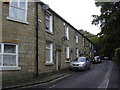
Stubbins Vale Terrace
Set in an elevated position above Stubbins is this row of Victorian terraced houses on Stubbins Vale Terrace.
For future reference the far end house was on the market for £295,000 in April 2007
For more information about the Ramsbottom area click on http://web.archive.org/web/20051218151821/http://www.ramsbottom.net/history.htm
Ramsbottom Heritage Society click http://www.ramsbottomheritage.co.uk/
Image: © Paul Anderson
Taken: 2 May 2007
0.01 miles

7
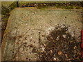
Floor
This is part of the floor of one of the three houses which the Porritt family built, this and a bit more are all what is left. The walls of the house up to floor level also exist. The other two houses are still lived in.
Image: © Alexander P Kapp
Taken: 1 Apr 2009
0.05 miles

9

Stubbins Mill and Holcombe Hill
Looking across the valley towards the paper mill, formerly Fort Stirling, now operated by Georgia-Pacific. In the background is Peel tower on Harcles Hill (known locally as "Holcombe Hill")
Image: © David Dixon
Taken: 25 Jun 2010
0.07 miles
