IMAGES TAKEN NEAR TO
The Drive, BURY, BL0 0LE
Introduction
This page details the photographs taken nearby to The Drive, BL0 0LE by members of the Geograph project.
The Geograph project started in 2005 with the aim of publishing, organising and preserving representative images for every square kilometre of Great Britain, Ireland and the Isle of Man.

There are currently over 7.5m images from over14,400 individuals and you can help contribute to the project by visiting https://www.geograph.org.uk
Image Map
Images are licensed for reuse under creativecommons.org/licenses/by-sa/2.0
Notes
- Clicking on the map will re-center to the selected point.
- The higher the marker number, the further away the image location is from the centre of the postcode.
Image Listing (115 Images Found)
Images are licensed for reuse under creativecommons.org/licenses/by-sa/2.0
Image
Details
Distance
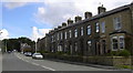
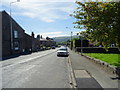
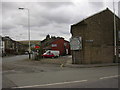
2
Houses on the junction of Bolton Road North and Bury Road
Image: © JThomas
Taken: 25 Sep 2018
0.04 miles
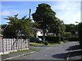
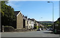
4
Bolton Road North, Edenfield
Looking south west.
Image: © JThomas
Taken: 25 Sep 2018
0.04 miles
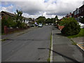
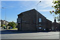
9
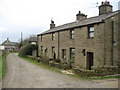
Eden Street Edenfield
These semi detached cottages in Edenfield are located on Eden Street.
The track to the left of the picture takes you down to Image which is approximately 400 yards away.
Image: © Paul Anderson
Taken: 13 Mar 2007
0.06 miles