IMAGES TAKEN NEAR TO
Whalley Road, BURY, BL0 0ER
Introduction
This page details the photographs taken nearby to Whalley Road, BL0 0ER by members of the Geograph project.
The Geograph project started in 2005 with the aim of publishing, organising and preserving representative images for every square kilometre of Great Britain, Ireland and the Isle of Man.

There are currently over 7.5m images from over14,400 individuals and you can help contribute to the project by visiting https://www.geograph.org.uk
Image Map
Images are licensed for reuse under creativecommons.org/licenses/by-sa/2.0
Notes
- Clicking on the map will re-center to the selected point.
- The higher the marker number, the further away the image location is from the centre of the postcode.
Image Listing (35 Images Found)
Images are licensed for reuse under creativecommons.org/licenses/by-sa/2.0
Image
Details
Distance
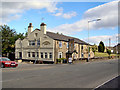
1
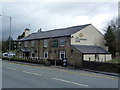
The Duckworth Arms
On the A56 south of Edenfield.
Image: © John H Darch
Taken: 22 Mar 2014
0.09 miles
4
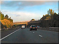
M66, Access Bridge, Woodhill Farm
Bridge carrying the private road between Woodhill Farm and Woodhill House.
Image: © David Dixon
Taken: 7 Oct 2010
0.13 miles
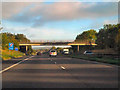
5
M66, Leaches Road Bridge
Bridge taking Leaches Road over the M66.
Image: © David Dixon
Taken: 7 Oct 2010
0.14 miles
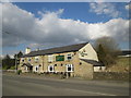
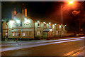
6
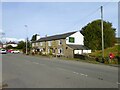
Duckworth Arms
On Whalley Road between Shuttleworth and Edenfield
Image: © Kevin Waterhouse
Taken: 17 Oct 2023
0.14 miles
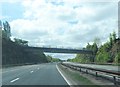
7
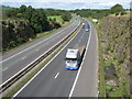
M66 Ramsbottom
Looking north from Image
This 'Northern Section' of the M66 was completed and opened to traffic in May 1978.
Because of the nature of the rock in this area it was found possible to design the side slopes to a very steep angle of 4 in 1.
Blasting was required to excavate the cutting and a pre-splitting technique was specified to obtain an even appearance to the rock face.
Source The Motorway Archive https://web.archive.org/web/20150124215637/http://www.ciht.org.uk/motorway/m66buryebp.htm
Image: © Paul Anderson
Taken: 18 Sep 2007
0.14 miles
8
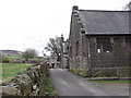
St John in the Wilderness Buildings, Leaches Road, Shuttleworth, Lancashire
Image: © Robert Wade
Taken: 1 Apr 2011
0.15 miles
9
The Duckworth Arms
A JW Lees pub/restaurant on Whalley Road.
Image: © David Dixon
Taken: 19 Jun 2010
0.15 miles
10
The Duckworth Arms
A JW Lees pub/restaurant on Whalley Road (A56) at Shuttleworth.
Image: © David Dixon
Taken: 30 Jan 2013
0.15 miles