IMAGES TAKEN NEAR TO
Muscliffe Lane, BOURNEMOUTH, BH9 3NL
Introduction
This page details the photographs taken nearby to Muscliffe Lane, BH9 3NL by members of the Geograph project.
The Geograph project started in 2005 with the aim of publishing, organising and preserving representative images for every square kilometre of Great Britain, Ireland and the Isle of Man.

There are currently over 7.5m images from over14,400 individuals and you can help contribute to the project by visiting https://www.geograph.org.uk
Image Map (Loading...)


Getting Data...Please wait
Leaflet Map data © OpenStreetMap
Images are licensed for reuse under creativecommons.org/licenses/by-sa/2.0
Notes
- Clicking on the map will re-center to the selected point.
- The higher the marker number, the further away the image location is from the centre of the postcode.
Image Listing (91 Images Found)
Images are licensed for reuse under creativecommons.org/licenses/by-sa/2.0
Image
Details
Distance
1
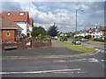
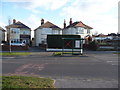
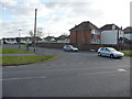
Bournemouth : Muscliffe Road & Strathmore Road junction
A road junction between the two roads in the north of Bournemouth.
Image: © Lewis Clarke
Taken: 6 Jun 2008
0.02 miles
2
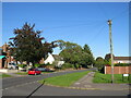
Bournemouth : Muscliff - Muscliffe Lane
Muscliffe Lane taken on the junction with Strathmore Road.
Image: © Lewis Clarke
Taken: 11 Feb 2010
0.05 miles
3
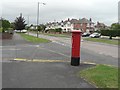
Muscliff: postbox № BH9 263, Muscliffe Lane
Here, we look northeast along Muscliffe Lane, past this George VI-reign postbox on the corner of Strathmore Road.
Image: © Chris Downer
Taken: 18 Jul 2008
0.06 miles
4
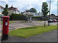
Bournemouth : Muscliffe Lane & Postbox
A postbox and bus stop on Muscliffe Lane
Image: © Lewis Clarke
Taken: 6 Jun 2008
0.07 miles
5
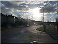
Bournemouth : Muscliff - Muscliff Lane Bus Shelter
I'm sure there used to be glass where that big X is - unless it's just an advert for Britain's Got Talent.
Image: © Lewis Clarke
Taken: 11 Feb 2010
0.07 miles
6
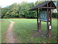
Stour Valley Nature Reserve
This is the entrance to the reserve with the information board in the foreground.
Image: © Stuart Buchan
Taken: 13 Oct 2005
0.07 miles
7
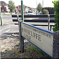
Muscliff: Muscliffe Lane
Notwithstanding the labelling of the Ordnance Survey's maps, the suburb of Muscliff rightly does not have an 'e' on the end, although it did develop over the second half of the 20th century and it stuck in the name of Muscliffe Lane, which we see here from its start on the busy A3060 Castle Lane West.
The bench faces a service road for a parade of shops on Castle Lane West.
The sign is an early version of a standard Bournemouth design from around 2000, the early version recognisable by a slightly more emboldened typeface, aligned to the left when on two lines: Shorter names lead to a large gap on the right-hand side of the sign (Owls Road in Boscombe is the champion in this respect), so perhaps that is why the centred text evolved.
This is photo no.287 of a series of 453 in my coronavirus lockdown walking project:
See Link for the complete set of photos.
Image: © Chris Downer
Taken: 10 Apr 2020
0.07 miles
8
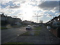
Bournemouth : Muscliff - Muscliffe Lane
Muscliffe Lane at 3.20pm on a February afternoon.
Image: © Lewis Clarke
Taken: 11 Feb 2010
0.08 miles
9
Muscliffe Lane, Muscliff, Bournemouth
Muscliffe Lane is a residential road in the northern outskirts of Bournemouth. It is in a district named Muscliff, some maps spell this Muscliffe (note the additional 'e' at the end)
Image: © Malc McDonald
Taken: 5 Oct 2024
0.08 miles
10
Bournemouth : Muscliff - Cox Avenue
Cox Avenue at the road junction with Muscliffe Lane.
Image: © Lewis Clarke
Taken: 11 Feb 2010
0.09 miles