IMAGES TAKEN NEAR TO
Comber Road, BOURNEMOUTH, BH9 2XG
Introduction
This page details the photographs taken nearby to Comber Road, BH9 2XG by members of the Geograph project.
The Geograph project started in 2005 with the aim of publishing, organising and preserving representative images for every square kilometre of Great Britain, Ireland and the Isle of Man.

There are currently over 7.5m images from over14,400 individuals and you can help contribute to the project by visiting https://www.geograph.org.uk
Image Map (Loading...)


Getting Data...Please wait
Leaflet Map data © OpenStreetMap
Images are licensed for reuse under creativecommons.org/licenses/by-sa/2.0
Notes
- Clicking on the map will re-center to the selected point.
- The higher the marker number, the further away the image location is from the centre of the postcode.
Image Listing (111 Images Found)
Images are licensed for reuse under creativecommons.org/licenses/by-sa/2.0
Image
Details
Distance
1
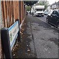
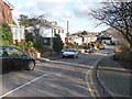
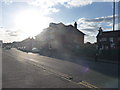
Moordown: Comber Road
One of the several west-east roads in Moordown, crossing between The Grove, The Avenue and Wimborne Road which run north-south. Some of these roads have two segments, but Comber Road is one of the single-segment roads. The houses in the background, desirable detached ones, exemplify the whole area.
The road sign is a standard one from around 2000-2006, perhaps a little earlier, featuring the borough coat of arms.
This is photo no.79 of a series of 453 in my coronavirus lockdown walking project:
See https://www.geograph.org.uk/article/My-2020-Coronavirus-Lockdown-walking-project for the complete set of photos.
Image: © Chris Downer
Taken: 17 Apr 2020
0.03 miles
2
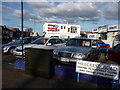
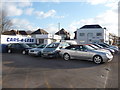
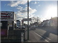
Bournemouth : Moordown - Cars-4-Less & Mike Stokes
Two automobile businesses side by side on Wimborne Road.
Image: © Lewis Clarke
Taken: 11 Feb 2010
0.04 miles
3
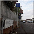
Moordown: Marks Road
One of numerous east-west roads which run from Wimborne Road across The Avenue to The Grove – except that Marks Road is the only one which is a dead end. It runs east from The Avenue, almost but not quite reaching Wimborne Road. It is, however, typical of the area in having decent detached houses form the early 20th century.
The sign is the standard Bournemouth nameplate from the 1980s, affixed with tubular steel which protrudes at each side.
This is photo no.263 of a series of 453 in my coronavirus lockdown walking project:
See https://www.geograph.org.uk/article/My-2020-Coronavirus-Lockdown-walking-project for the complete set of photos.
Image: © Chris Downer
Taken: 17 Apr 2020
0.04 miles
4
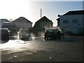
Moordown: at the carwash
Looking diagonally across a former car showroom forecourt, now occupied by a popular hand carwash and valeting service. The spray is catching the sunlight interestingly as we look directly against the sun - especially the car left of centre, whose shadow encroaches across the spray.
Image: © Chris Downer
Taken: 28 Jan 2016
0.04 miles
5
Bournemouth : Moordown - Cars-4-Less
Used car dealership on Wimborne Road.
Image: © Lewis Clarke
Taken: 11 Feb 2010
0.05 miles
6
Bournemouth : Moordown - Meadow Court Close
A downhill road off Wimborne Road to more houses.
Image: © Lewis Clarke
Taken: 11 Feb 2010
0.05 miles
7
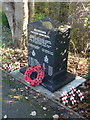
Moordown: the Halifax Memorial
Pictured on Remembrance Sunday, 11 November 2012, the Moordown Halifax Memorial was unveiled on 10 July 2011 and stands on the corner of the main Wimborne Road and Meadow Court Close. It is inscribed:
In memory of the two local residents and seven aircrew who lost their lives in the cause of freedom when RAF Halifax bomber JP 137 crashed at this location on 21st March 1944.
Mrs Dorothea Bennett, Flat 9 Meadow Court
Mr Percy F. Chislett, 1027 Wimborne Road
Sgt. Denis R. Evans, Pilot, RAFVR
Sgt. Henry W. Roberts, Nav., RAFVR
F/O Stanley A. Appleton, B/A, RAFVR
Sgt. George A. Alexander, W/Op., RAFVR
Sgt. Stanley F. Gent, F/E, RAFVR
Sgt. Kenneth Green, A/G, RAFVR
Sgt. Reginald R. McGREGOR, A/G, RCAF
LEST WE FORGET
Organised by the Moordown 2010 Committee
as a contribution to the bicentenary of Bournemouth
Meadow Court is the block of flats immediately behind the memorial (Image), while 1027 Wimborne Road would have been on the opposite corner.
An excecllent account of the event in 1944 can be found on the Winton Forum website here: http://www.wintonforum.co.uk/halifax.html
Image: © Chris Downer
Taken: 11 Nov 2012
0.05 miles
8
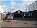
Bournemouth : Moordown - Mike Stokes Motoring Garage
Maybe that is Mike Stokes standing in his own garage - I guess we'll never know.
Image: © Lewis Clarke
Taken: 11 Feb 2010
0.05 miles
9
Bournemouth : Moordown - Wimborne Road
A man crosses the road with the Holly Tree pub behind him.
Image: © Lewis Clarke
Taken: 11 Feb 2010
0.05 miles
10
Bournemouth : Moordown - Wimborne Road
Welcome to Moordown, with Mike Stokes motorcycle shop on the left.
Image: © Lewis Clarke
Taken: 11 Feb 2010
0.06 miles