IMAGES TAKEN NEAR TO
Hawthorn Road, BOURNEMOUTH, BH9 2QR
Introduction
This page details the photographs taken nearby to Hawthorn Road, BH9 2QR by members of the Geograph project.
The Geograph project started in 2005 with the aim of publishing, organising and preserving representative images for every square kilometre of Great Britain, Ireland and the Isle of Man.

There are currently over 7.5m images from over14,400 individuals and you can help contribute to the project by visiting https://www.geograph.org.uk
Image Map
Images are licensed for reuse under creativecommons.org/licenses/by-sa/2.0
Notes
- Clicking on the map will re-center to the selected point.
- The higher the marker number, the further away the image location is from the centre of the postcode.
Image Listing (161 Images Found)
Images are licensed for reuse under creativecommons.org/licenses/by-sa/2.0
Image
Details
Distance
1
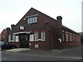
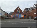
Winton: Elim Church
A small church in Hawthorn Road, just off the main Wimborne Road.
Image: © Chris Downer
Taken: 24 Feb 2008
0.02 miles
2
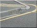
Winton: kerbstone with road name inscribed
Many of the turnings off Wimborne Road, Winton's main street, were given these kerbstones many years ago; you can see that, when the council has subsequently re-laid the kerb, it has kept the inscribed ones untouched.
Image: © Chris Downer
Taken: 28 Jul 2007
0.02 miles
3
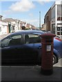
Winton: postbox № BH9 96, Wimborne Road
This Edward VII-reign postbox stands in the shade in the afternoon, being on the western side of Image, while properties in Calvin Road, ahead, catch the sun. Right of picture is the side of Image
Image: © Chris Downer
Taken: 6 Jul 2008
0.03 miles
4
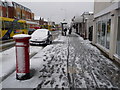
Winton: snow-spattered postbox
Two days after heavy snow earlier in the week had all thawed, this fresh lot came down this morning, despite the fact that the day started rainy, with large puddles all around. As can be seen from the postbox, it was coming squarely from the north. For the same view 4 hours later, see Image
By nightfall, the main carriageways of all roads were clear of snow and ice, so this was a very heavy fall considering that it started and had almost disappeared on the same day.
Image: © Chris Downer
Taken: 6 Feb 2009
0.03 miles
5
Winton Christadelphian Church
On Wimborne Road. http://www.wintonchristadelphians.org/
Image: © Mike Faherty
Taken: 6 Jan 2012
0.03 miles
6
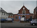
Winton: Christadelphian Church
Situated on Wimborne Road, the main road through Winton, between numbers 572 and 580.
Image: © Chris Downer
Taken: 24 Feb 2008
0.03 miles
7
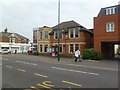
Winton Liberal Club
On Wimborne Road, at the corner of Calvin Road; with a foundation stone dated 1913.
Image: © Mike Faherty
Taken: 6 Jan 2012
0.04 miles
8
Winton: the thaw begins
A very similar view to the one here four hours earlier: Image But the postbox is no longer snow-spattered and the road no longer hazardous.
The pavement has become rather more slushy, though, and would freeze in this state later; but the roads once cleared did not freeze over in the following night.
The car, I notice, is the same one that was in the previous image so it has either outstayed the 30-minute daytime parking limit or it has returned.
Image: © Chris Downer
Taken: 6 Feb 2009
0.04 miles
9
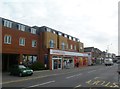
Winton, Sainsbury's Local
Opened in September 2008, on Wimborne Road.
Image: © Mike Faherty
Taken: 6 Jan 2012
0.04 miles
10
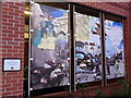
Winton: mural at Sainsbury?s
This mural was designed by students on a vocational arts course at nearby Winton Arts & Media College (formerly Winton Boys' School - see Image and is displayed by the car-park entrance of Sainsbury's (see Image; it is just to the left of the main door and is visible in Image).
Among the recognisable buildings featured are Winton Library (in the left-hand panel; see Image) and the corner piece of the Plaza, predecessor to the former Continental cinema (in the middle panel; the Continental is now occupied by Image).
Image: © Chris Downer
Taken: 16 Mar 2013
0.04 miles