IMAGES TAKEN NEAR TO
Wimborne Road, BOURNEMOUTH, BH9 2HN
Introduction
This page details the photographs taken nearby to Wimborne Road, BH9 2HN by members of the Geograph project.
The Geograph project started in 2005 with the aim of publishing, organising and preserving representative images for every square kilometre of Great Britain, Ireland and the Isle of Man.

There are currently over 7.5m images from over14,400 individuals and you can help contribute to the project by visiting https://www.geograph.org.uk
Image Map
Images are licensed for reuse under creativecommons.org/licenses/by-sa/2.0
Notes
- Clicking on the map will re-center to the selected point.
- The higher the marker number, the further away the image location is from the centre of the postcode.
Image Listing (99 Images Found)
Images are licensed for reuse under creativecommons.org/licenses/by-sa/2.0
Image
Details
Distance
1
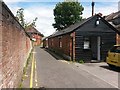
Winton: footpath A16 passes Michael Grubb Studio
A picture a little way along from Image], showing this public footpath as it passes what was presumably originally a garage or outbuilding of one of the shops (or flats above) in Wimborne Road. Michael Grubb Studio is a crative lighting company and it is one of the very few postal addresses in Bryanstone Walk.
See Image for a view towards us from just beyond the bend ahead.
Image: © Chris Downer
Taken: 28 Jun 2016
0.01 miles
2
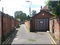
Winton: stripy garage in Bryanstone Walk
Looking along Bryanstone Walk, public footpath A16, towards Bryanstone Road.
See Image] for a view towards us from just ahead, and Image for the view behind us onto Talbot Road.
Image: © Chris Downer
Taken: 28 Jun 2016
0.01 miles
3
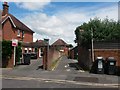
Winton: Bryanstone Walk from Bryanstone Road
The driveway ahead is essentially a rear access for shops in Wimborne Road. It also forms public footpath A16. See Image for the next picture along the path.
Image: © Chris Downer
Taken: 28 Jun 2016
0.02 miles
4
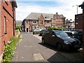
Winton: Bryanstone Walk arrives at Talbot Road
This lane is a rear access driveway for shops and flats in Wimborne Road, and is also public footpath A16. We look at its northern end, emerging onto Talbot Road by the main Winton Banks junction. The junction is so called because of the banks on the corner - the former Lloyds Bank across the road, and the NatWest, which still operates here, across whose car park we are looking diagonally.
Image: © Chris Downer
Taken: 28 Jun 2016
0.02 miles
5
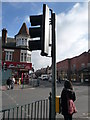
Bournemouth : Pedestrian Crossing on Wimborne Road
Pizza Hut and the Hop & Kilderkin pub can be seen here. The road junction leads to Alma Road.
Image: © Lewis Clarke
Taken: 13 Feb 2009
0.02 miles
6
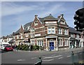
Winton, Hop & Kilderkin
Greene King pub at the corner of Talbot and Wimborne Roads. Internally, bar to right, eating & drinking area to front and left on two levels; TV. Cask ales on offer at my visit: Abbot, IPA, Ringwood Fortyniner. For some customer comments, see http://www.beerintheevening.com/pubs/s/13/1398/Hop_and_Kilderkin/Winton
Image: © Mike Faherty
Taken: 1 Sep 2010
0.03 miles
7
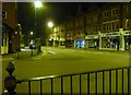
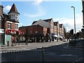
Bournemouth : Winton - Wimborne Road
Wimborne Road at 2.40am on a Friday morning. Nobody is up and about yet - apart from me.
Image: © Lewis Clarke
Taken: 19 Feb 2010
0.03 miles
8
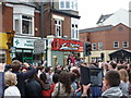
Winton: the Olympic flame turns into Alma Road
It is day 56 of the Olympic torch relay and we see the flame being carried into Alma Road, having come along Wimborne Road, the main thoroughfare through Winton. Crowds came out to suppoprt the torch bearers, while some people could just look out of their upstair windows.
Image: © Chris Downer
Taken: 13 Jul 2012
0.03 miles
9
Winton, language school
Capital School of English, on the corner of Alma and Wimborne Roads. http://www.capitalschool.co.uk/
Image: © Mike Faherty
Taken: 1 Sep 2010
0.03 miles
10
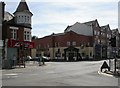
Winton: The Hop & Kilderkin
A pub of the Hogshead chain at Image, occupying the site of the former Continental cinema, which fell into disuse in the 1980s and was redeveloped a few years later.
A history of the cinema is told here: http://www.wintonforum.co.uk/cinemas.html
Image: © Chris Downer
Taken: 23 Mar 2008
0.03 miles