IMAGES TAKEN NEAR TO
Wimborne Road, BOURNEMOUTH, BH9 2ET
Introduction
This page details the photographs taken nearby to Wimborne Road, BH9 2ET by members of the Geograph project.
The Geograph project started in 2005 with the aim of publishing, organising and preserving representative images for every square kilometre of Great Britain, Ireland and the Isle of Man.

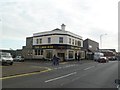
There are currently over 7.5m images from over14,400 individuals and you can help contribute to the project by visiting https://www.geograph.org.uk
Image Map (Loading...)


Getting Data...Please wait
Leaflet Map data © OpenStreetMap
Images are licensed for reuse under creativecommons.org/licenses/by-sa/2.0
Notes
- Clicking on the map will re-center to the selected point.
- The higher the marker number, the further away the image location is from the centre of the postcode.
Image Listing (170 Images Found)
Images are licensed for reuse under creativecommons.org/licenses/by-sa/2.0
Image
Details
Distance
1
Winton, Silverback
Recently opened micropub and alehouse on Wimborne Road. Internally, a single room, with tables and benches (former church pews?) left and right. Stillage room (beer served by gravity) back right; minimal decoration, in the form of a few modern paintings. On offer at my visit: five cask ales from local breweries, cider, English wine & gin. https://www.facebook.com/thesilverbackalehousewinton/home?ref=page_internal
Image: © Mike Faherty
Taken: 6 Aug 2016
0.01 miles
2
Winton, former fire station
On Wimborne Road, showing an attention to detail not found in modern stations. Behind the central gate is a courtyard; left and right, with stone surrounds, public conveniences, now closed, as is the case with most of Bournemouth's conveniences.
Image: © Mike Faherty
Taken: 6 Jan 2012
0.01 miles
3
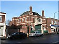
Winton: former fire station, former toilets
The demolition of the neighbouring building offers a rare view of the complete building. This was actually built as a combined fire station and public convenience (using the two front doors on either side) and closed in 1960 when Image was opened. It is now used as a storeroom. The toilets themselves closed in 2007.
The history of the building is told in detail here: http://www.wintonforum.co.uk/firehistory.html
Image: © Chris Downer
Taken: 26 Dec 2007
0.01 miles
4
Winton, First Point
Council-operated information and resource centre on Wimborne Road, with a plaque dated 1930. http://www.bournemouth.gov.uk/SocialCareHealth/Peoplewithmentalhealthneeds/FirstPoint.aspx
Image: © Mike Faherty
Taken: 6 Jan 2012
0.02 miles
5
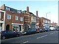
Winton, The Lark Rise
Pub on Wimborne Road, at the corner of Luther Road. Recently renamed (from The Pines) and refurbished; curving central bar, drinking and eating areas left, front, right; raised sitting areas, darts, pool, TV, jukebox, games machines. Cask ale on offer at my visit: Ringwood Best. http://www.larkrisepubbournemouth.co.uk/
Image: © Mike Faherty
Taken: 6 Jan 2012
0.02 miles
6
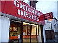
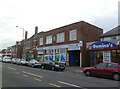
Bournemouth : Winton - Chicken Delite
Every time I pass this on Wimborne Road I wonder why it's spelled wrong - it's not like they don't have enough space.
Image: © Lewis Clarke
Taken: 18 Nov 2009
0.03 miles
8
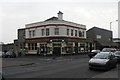
Winton: The Famous Old Pines
This was The Pines until it underwent a refurbishment in 1999 and tried to become a pre-club bar type place (although there are no nearby nightclubs). It has since reverted from its new name of The Glasshouse, back to the Pines, but with an odd "Famous Old" bit added. It is at 475 Wimborne Road, on the corner of Luther Road.
Image: © Chris Downer
Taken: 24 Feb 2008
0.03 miles
9
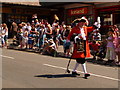
Winton: town cryer leads the carnival parade
The town crier of Poole (I don't think Bournemouth has its own) leads the carnival procession through the main street of Winton, Wimborne Road.
Image: © Chris Downer
Taken: 26 Jun 2010
0.03 miles
10
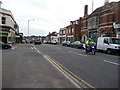
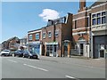
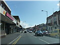
Bournemouth : Winton - Wimborne Road
I was waiting for a bus when I took this photo, possibly as a way of passing the time.
Image: © Lewis Clarke
Taken: 3 Mar 2010
0.03 miles