
IMAGES TAKEN NEAR TO
Wimborne Road, BOURNEMOUTH, BH9 2DW
Introduction
This page details the photographs taken nearby to Wimborne Road, BH9 2DW by members of the Geograph project.
The Geograph project started in 2005 with the aim of publishing, organising and preserving representative images for every square kilometre of Great Britain, Ireland and the Isle of Man.

There are currently over 7.5m images from over14,400 individuals and you can help contribute to the project by visiting https://www.geograph.org.uk
Image Map
Images are licensed for reuse under creativecommons.org/licenses/by-sa/2.0
Notes
- Clicking on the map will re-center to the selected point.
- The higher the marker number, the further away the image location is from the centre of the postcode.
Image Listing (99 Images Found)
Images are licensed for reuse under creativecommons.org/licenses/by-sa/2.0
Image
Details
Distance
1
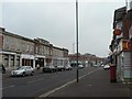
Moordown: The Strand
Looking across Wimborne Road towards a parade of shops called The Strand, according to the remains of the lettering in its centre, encompassing even numbers 898-912.
Visible on this side of the road is Image
Image: © Chris Downer
Taken: 24 Feb 2008
0.01 miles
2
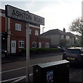
Moordown: Ashton Road
Looking along Ashton Road from the main Wimborne Road. When I was growing up in the 1980s, all the side turnings had these double-facing name signs on high posts: quite a few 80s signs survive, as here, while others have been replaced on the same tall posts and some have been replaced by more traditional low-level signs.
This is photo no.20 of a series of 451 in my coronavirus lockdown walking project:
See https://www.geograph.org.uk/article/My-2020-Coronavirus-Lockdown-walking-project for the complete set of photos.
Image: © Chris Downer
Taken: 17 Apr 2020
0.02 miles
3
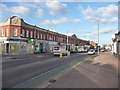
Bournemouth : Moordown - Wimborne Road
This road has several independent businesses from the Laundrette to Roger's Opticians.
Image: © Lewis Clarke
Taken: 11 Feb 2010
0.02 miles
4
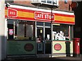
Moordown: postbox № BH9 144, Wimborne Road, and post office
This postbox was repositioned here when the post office joined these premises (see Image). It replaced two – one which was on the next corner south, by Cowper Road, and one that was at the far end of Tennyson Road, the next turning north.
Image: © Chris Downer
Taken: 3 Jul 2008
0.02 miles
5
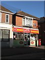
Moordown: post office
Moordown's post office used to be further up Wimborne Road, on the other side (see Image), but closed for a time when the postmistress was found to be defrauding the business, during the 1990s. After a year without a branch in Moordown, it reopened here.
I note that the shop is called 'Late Stop' but it is closed, now, at 7 o'clock on a Thursday evening.
Image: © Chris Downer
Taken: 3 Jul 2008
0.02 miles
6
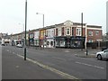
Moordown: Grand Parade
Even numbers 870-892 Wimborne Road. The parade is dated 1924 on the gable and runs from Cowper to Ashton Roads.
Image: © Chris Downer
Taken: 24 Feb 2008
0.04 miles
7
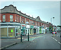
Tennyson Buildings
Parade of shops dating from 1926
Image: © Chris Gunns
Taken: 25 May 2009
0.04 miles
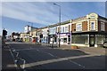
9
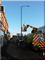
Moordown: Christmas dismantlement
Looking along the main Wimborne Road as the electricity board remove the festive adornments to the lampposts. They were turned off on 5 January, of course, but it takes a while before the festive lights are physically removed.
Image: © Chris Downer
Taken: 28 Jan 2016
0.05 miles
10
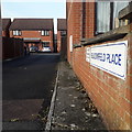
Moordown: Bloomfield Place
A mid-1990s infill development towards the western end of Bloomfield Avenue, whose sign, from a distance, resembles the standard borough nameplate of the time (see for example Image) – but in fact it isn't, so presumably it was erected by the developer rather than the council.
This is photo no.42 of a series of 453 in my coronavirus lockdown walking project:
See https://www.geograph.org.uk/article/My-2020-Coronavirus-Lockdown-walking-project for the complete set of photos.
Image: © Chris Downer
Taken: 17 Apr 2020
0.06 miles