IMAGES TAKEN NEAR TO
Evelyn Road, BOURNEMOUTH, BH9 1SU
Introduction
This page details the photographs taken nearby to Evelyn Road, BH9 1SU by members of the Geograph project.
The Geograph project started in 2005 with the aim of publishing, organising and preserving representative images for every square kilometre of Great Britain, Ireland and the Isle of Man.

There are currently over 7.5m images from over14,400 individuals and you can help contribute to the project by visiting https://www.geograph.org.uk
Image Map (Loading...)


Getting Data...Please wait
Leaflet Map data © OpenStreetMap
Images are licensed for reuse under creativecommons.org/licenses/by-sa/2.0
Notes
- Clicking on the map will re-center to the selected point.
- The higher the marker number, the further away the image location is from the centre of the postcode.
Image Listing (101 Images Found)
Images are licensed for reuse under creativecommons.org/licenses/by-sa/2.0
Image
Details
Distance
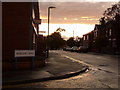
1
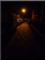
Moordown: footprints in the snow in Garth Road
Snowy footprints on the approach to a lamppost on this short residential street.
Image: © Chris Downer
Taken: 2 Feb 2009
0.05 miles
2

As contemporary as you can get
This dwelling in Muscliffe Road, Moordown, is just nearing completion and has been adorned with a date stone for 2007 – the first one I have seen.
Image: © Chris Downer
Taken: 15 Jul 2007
0.05 miles
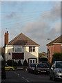
3
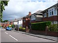
Endfield Road, Bournemouth
This is the view south of these 1930's houses in Endfield Rd close to the junction with Coronation Avenue.
Image: © Nigel Mykura
Taken: 28 Aug 2009
0.05 miles
4
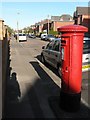
Moordown: postbox № BH9 134, Limited Road
Looking along Limited Road, a small residential street, from its western end.
This George V-reign postbox is my local one. Returning home from a fortnight's holiday a couple of years ago, I came here to post a letter only to find a square of tarmac where the postbox had stood – I am pleased to report it was reinstated a few months later.
Image: © Chris Downer
Taken: 3 Jul 2008
0.08 miles
5
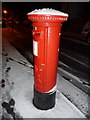
Moordown: snow-capped postbox
Image does not often have this appearance; it followed Bournemouth's heaviest snowfall for some years, occurring overnight and today. The picture was taken at about 10 o'clock in the evening.
Image: © Chris Downer
Taken: 2 Feb 2009
0.08 miles
6
Winton: Castle Road
Looking along the western half of Castle Road from the Muscliffe Road crossroads. After an overcast and drizzly day, the sun finally decided to make an appearance at about 8pm, from under the immediate cloud cover.
Image: © Chris Downer
Taken: 29 Jul 2009
0.08 miles
7
Winton: chimneypot shadows
Looking along the northern segment of Benmore Road towards a house in Brassey Road whose roof is hosting an interesting shadow of a nearby chimney.
Image: © Chris Downer
Taken: 23 Nov 2008
0.09 miles
8
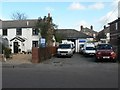
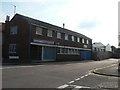
Winton: United Fish Services
Cod makes its way from the vastness of the North Sea to this unassuming fishery behind a cottage in Castle Road.
The company has several vehicles with personalised number plates – such as all three visible here – bearing the initials UFS.
Image: © Chris Downer
Taken: 1 Mar 2008
0.12 miles
9
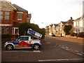
Winton: Benmore and Castle Roads meet
Looking along Castle Road from the Benmore Road crossroads. The distinctive Mini, with its advert for the Red Bull drink shaped like a tin can, must live somewhere near here as it is a frequent sight. As far as I know, the car does not have wings.
Image: © Chris Downer
Taken: 6 Sep 2009
0.13 miles
10
Winton: Sunlight laundry
The Sunlight laundry is on the evens side of Castle Road and thus stunts the progress of the even numbers considerably, compared to the odds. The nearer part of the building used to be a television retailer but is now a westerns dress hire outlet, a surprisingly narrow remit. The entrance to the laundry can be seen farther down, and the chimney is theirs too.
Image: © Chris Downer
Taken: 8 Jun 2008
0.13 miles