IMAGES TAKEN NEAR TO
Cranmer Road, BOURNEMOUTH, BH9 1JT
Introduction
This page details the photographs taken nearby to Cranmer Road, BH9 1JT by members of the Geograph project.
The Geograph project started in 2005 with the aim of publishing, organising and preserving representative images for every square kilometre of Great Britain, Ireland and the Isle of Man.

There are currently over 7.5m images from over14,400 individuals and you can help contribute to the project by visiting https://www.geograph.org.uk
Image Map (Loading...)


Getting Data...Please wait
Leaflet Map data © OpenStreetMap
Images are licensed for reuse under creativecommons.org/licenses/by-sa/2.0
Notes
- Clicking on the map will re-center to the selected point.
- The higher the marker number, the further away the image location is from the centre of the postcode.
Image Listing (163 Images Found)
Images are licensed for reuse under creativecommons.org/licenses/by-sa/2.0
Image
Details
Distance
1
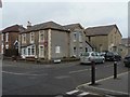
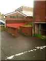
Winton: Moose Hall
Situated at 16a Wycliffe Road, on the corner of Cranmer Road. The chapel-like building alongside is now an engineering company's premises but was the Apostolic Church according to the Kelly's Directory of 1975.
Image: © Chris Downer
Taken: 24 Feb 2008
0.02 miles
2
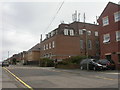
Winton, telephone exchange
In Wycliffe Road, one of several local roads named after Protestant churchmen. Part of the buildings is also used as a training centre http://www.thecollege.co.uk/news/article.php?nid=22
Image: © Mike Faherty
Taken: 26 Mar 2009
0.06 miles
3
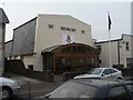
Winton: Salvation Army
The Salvation Army buildings in Latimer Road. The place next door (to the right) is called The Place Next Door and is the Sally Army's charity shop.
Image: © Chris Downer
Taken: 24 Feb 2008
0.06 miles
4
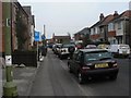
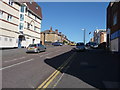
Winton: Junction Road
An unusual house numbering system exists in Junction Road – as we look along from its southern end, we see on our left numbers 1, 2 and 3; and on the right, even numbers 4, 6, 8 and 10.
On the Ordnance Survey large scale map of 1898, and when Winton was still a separate village before it became a suburb of Bournemouth, only the left-hand houses appear, so this may explain the unorthodox numbering.
Image: © Chris Downer
Taken: 24 Feb 2008
0.06 miles
5
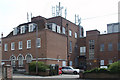
Winton Telephone Exchange
The exchange is in Wycliffe Road, Winton just behind the main shopping street. These buildings now support more and more mobile phone antennas.
Image: © Geoff Trim
Taken: 23 Apr 2009
0.06 miles
7
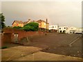
Winton: footpath L02 to Cranmer Road Car Park
Because this short public footpath adjoins the delivery yard for Wilkinsons, the Wetherspoon pub and the shops in between, in reality pedestrians tend to just walk through the yard as it is much easier (and is a shorter route for the majority who will be continuing along to the shops).
See Image for the next picture of the path, and Image for another picture showing how it reaches the car park.
Image: © Chris Downer
Taken: 22 Jun 2016
0.07 miles
8
Winton: footpath L02 alongside a delivery yard
Because this short public footpath adjoins the delivery yard for Wilkinsons, the Wetherspoon pub and the shops in between, in reality pedestrians tend to just walk through the yard as it is much easier (and is a shorter route for the majority who will be continuing along to the shops).
See Image for another picture from this spot, looking farther left to show the continuation of the path to Cranmer Road Car Park.
See Image for a picture of the path from the far end.
Image: © Chris Downer
Taken: 22 Jun 2016
0.07 miles
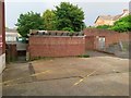
9
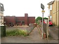
Winton: footpath L02 leaves Cranmer Road Car Park
This short public footpath leads from the southwest corner of the council-run car park, leading to Latimer Road. See Image for the next view, with notes on the continuing route.
The underground part of the car park, below Wilkinson's, is long disused. I'm not sure what the small building with the damaged window is.
Image: © Chris Downer
Taken: 22 Jun 2016
0.08 miles
10
Winton: footpath L02 enters and leaves the Wilko delivery yard
This is a funny little path, an official public right of way, which leads from Latimer Road (off to our right) to Cranmer Road Car Park (left).
Because there is no barrier between the path and the delivery yard of Wilkinson's and neighbours, most pedestrians will simply walk through the yard rather than go the far side of the railings to keep to the official route.
See Image for a picture from the same spot, viewing further to the right to see the path and yard come out on Latimer Road.
Meanwhile, see Image for a view of the path from the car park.
Image: © Chris Downer
Taken: 22 Jun 2016
0.08 miles