IMAGES TAKEN NEAR TO
Heron Court Road, BOURNEMOUTH, BH9 1DF
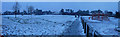
Introduction
This page details the photographs taken nearby to Heron Court Road, BH9 1DF by members of the Geograph project.
The Geograph project started in 2005 with the aim of publishing, organising and preserving representative images for every square kilometre of Great Britain, Ireland and the Isle of Man.

There are currently over 7.5m images from over14,400 individuals and you can help contribute to the project by visiting https://www.geograph.org.uk
Image Map
Images are licensed for reuse under creativecommons.org/licenses/by-sa/2.0
Notes
- Clicking on the map will re-center to the selected point.
- The higher the marker number, the further away the image location is from the centre of the postcode.
Image Listing (90 Images Found)
Images are licensed for reuse under creativecommons.org/licenses/by-sa/2.0
Image
Details
Distance
1
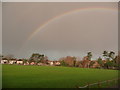
Winton: rainbow over the Rec
Looking across the northwest corner of Winton Rec football field – which is on a noticeable slope – as a large rainbow is superimposed on a dark grey sky. In fact, the faint outer band of the double rainbow can be seen.
Image: © Chris Downer
Taken: 25 Nov 2009
0.05 miles
2
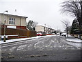
Winton: Truscott Avenue
In a fit of dare, Truscott Avenue breaks with the traditional criss-cross pattern of neighbouring roads, and crosses them diagonally for no apparent reason.
Two days after heavy snow earlier in the week had all thawed, this fresh lot fell from the north this morning, despite the fact that the day started rainy, with large puddles all around.
By nightfall, the main carriageways of all roads were clear of snow and ice, so this was a very heavy fall considering that it started and had almost disappeared on the same day.
Image: © Chris Downer
Taken: 6 Feb 2009
0.05 miles
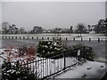
3
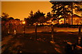
Bournemouth : Winton - Winton Rec
A playground in Winton Rec. If there were any children playing here at this hour than it would be a worry as it was 00:30.
Image: © Lewis Clarke
Taken: 5 Oct 2010
0.06 miles
4
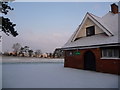
Winton: snow on the rec
A wintry scene at Image after Bournemouth's heaviest snowfall for many a year.
Image: © Chris Downer
Taken: 2 Feb 2009
0.06 miles
5
Bournemouth : Winton Recreational Park
Winton Recreation Ground is the only significant green space in an area of approximately one square mile, serving a population of some 4750 people.
Image: © Lewis Clarke
Taken: 6 Feb 2009
0.06 miles
6
Winton: the snow returns again
After the snowfall on February 2nd and the sequel on the 6th, we awoke to a belated encore this morning, a month later, unannounced by the forecast. It was shortlived, though, and almost all trace was gone by dusk.
Image: © Chris Downer
Taken: 5 Mar 2009
0.06 miles
7
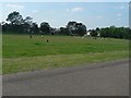
Winton: Winton Rec playing field
The playing field of Winton Rec used to be flat, with a stone wall on its south and eastern faces and steps up to the footpaths around it. It was re-landscaped in the late 1990s and the walls removed. As can be seen here, it is no longer completely flat – Heroon Court Road beyond meanders downhill from left to right – but it is still a popular place for a kickabout.
Image: © Chris Downer
Taken: 8 Jun 2008
0.06 miles
8
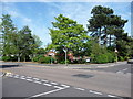
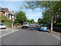
Bournemouth : Fitzharris Avenue & Heron Court Road
Image: © Lewis Clarke
Taken: 20 May 2009
0.07 miles
9
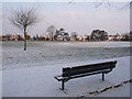
Winton: a bench at Winton Rec
This bench would normally provide a green outlook across Image but today it is all white after overnight snowfall.
Image: © Chris Downer
Taken: 2 Feb 2009
0.07 miles
10
Bournemouth : Winton - Fitzharris Avenue
Image: © Lewis Clarke
Taken: 20 May 2009
0.07 miles