IMAGES TAKEN NEAR TO
Castlepoint, Castle Lane West, BOURNEMOUTH, BH8 9UP
Introduction
This page details the photographs taken nearby to Castlepoint, Castle Lane West, BH8 9UP by members of the Geograph project.
The Geograph project started in 2005 with the aim of publishing, organising and preserving representative images for every square kilometre of Great Britain, Ireland and the Isle of Man.

There are currently over 7.5m images from over14,400 individuals and you can help contribute to the project by visiting https://www.geograph.org.uk
Image Map (Loading...)


Getting Data...Please wait
Leaflet Map data © OpenStreetMap
Images are licensed for reuse under creativecommons.org/licenses/by-sa/2.0
Notes
- Clicking on the map will re-center to the selected point.
- The higher the marker number, the further away the image location is from the centre of the postcode.
Image Listing (98 Images Found)
Images are licensed for reuse under creativecommons.org/licenses/by-sa/2.0
Image
Details
Distance
1
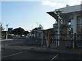
Strouden: West Village, Castlepoint
At the front of Castlepoint shopping centre are two small retail areas, West and East Village. This one comprises Jessop's and Lakeland.
Image: © Chris Downer
Taken: 22 Jun 2008
0.02 miles
2
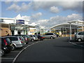
Castlepoint, West Village
Visually confusing, and stretching the concept of "village" to its extreme. For details, see http://www.castlepointshopping.com/Facilities.html
Image: © Mike Faherty
Taken: 10 Feb 2009
0.03 miles
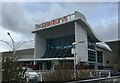
4

Sainsbury's Supermarket
Sainsbury's Supermarket opened in 2003 at Castlepoint Shopping Park, and is one of two grocery retailers in the park.
Image: © Mat Tuck
Taken: 14 Sep 2013
0.05 miles
5
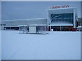
Snow logged car park
Castlepoint Shopping Park car park outside the Sainsbury's Supermarket. The upper deck was closed due to the snow and the inability to use standard methods of deicing due to the concrete fatigue.
Image: © Mat Tuck
Taken: 2 Dec 2010
0.05 miles
6
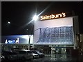
Sainsbury's Supermarket
Sainsbury's Supermarket located at the Castlepoint Shopping Park in Bournemouth. The store's front is adorned with illuminated Christmas decorations.
Image: © Mat Tuck
Taken: 27 Nov 2015
0.05 miles
7
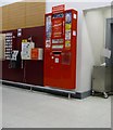
Strouden: postbox № BH8 402, Castlepoint
The only postbox in the Castlepoint shopping centre, it is located at the back of the tills in the Sainsbury's supermarket.
Image: © Chris Downer
Taken: 1 Jan 2009
0.05 miles
8
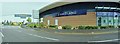
Bournemouth : Lakeland, Sainsbury's & Yeomans Road
Image: © Lewis Clarke
Taken: 27 Apr 2009
0.05 miles
9

Strouden: new car leaving Castlepoint
A quick opportunistic snap of a '60' registration plate on its first day of issue, while waiting for the lights to change.
The current registration system sees the two-digit year being issued from 1 March to 31 August, and the two-digit year +50 issued from 1 September to the following 28 (or 29) February. The first such issue was on 1 September 2001 - thus a '51' plate (and coincidentally England's football team beat Germany on that day by the score of 5-1). The system has the capacity to remain in force until 2050, when the components could be reversed and it could go for another 50 years. The first two letters denote the area (H is for Hampshire & Dorset with the first part of the alphabet in second position the more usual seen in this area), while the last three letters are random.
Here, the car is turning left out of Hamblin Way (named after a local man of eminence in the medical field, Dr. Terry Hamblin) which is the main road through the Castlepoint shopping centre. It is taking the most usual route out, with the main A3060 at the roundabout ahead, whose signage we see in the background. Traffic turning right, such as me, are going to the modern northern suburbs of town. The bus behind me, just visible in my wing mirror, is not in service but is bound for the bus depot which is in Yeomans Way, behind the shopping centre.
Image: © Chris Downer
Taken: 1 Sep 2010
0.05 miles
10
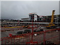
Castlepoint: reconstruction is underway
Castlepoint shopping centre was opened in 2003 and structural problems came to light soon after. Since December 2005 the lower deck of the car park has been reinforced with props, such as visible here: Image (July 2007) and I naively took follow-up photos in February 2008 (Image) and June 2008 (Image) expecting that it would be properly remedied soon after.
But 10 years on, something is finally being done. This is the view through the cordoned area - the frontage of Sainsbury's on the western end - where we can see that the top level has been demolished and the works to rebuild it have got started during the autumn of 2018.
Mitigating the loss of parking spaces, more car parking has been built under some of the shops.
See also Image
For a view across the Sainsbury's frontage from the car park before it was demolished, see Image
Image: © Chris Downer
Taken: 16 Dec 2018
0.06 miles