IMAGES TAKEN NEAR TO
Mallard Road, BOURNEMOUTH, BH8 9PW
Introduction
This page details the photographs taken nearby to Mallard Road, BH8 9PW by members of the Geograph project.
The Geograph project started in 2005 with the aim of publishing, organising and preserving representative images for every square kilometre of Great Britain, Ireland and the Isle of Man.

There are currently over 7.5m images from over14,400 individuals and you can help contribute to the project by visiting https://www.geograph.org.uk
Image Map (Loading...)


Getting Data...Please wait
Leaflet Map data © OpenStreetMap
Images are licensed for reuse under creativecommons.org/licenses/by-sa/2.0
Notes
- Clicking on the map will re-center to the selected point.
- The higher the marker number, the further away the image location is from the centre of the postcode.
Image Listing (99 Images Found)
Images are licensed for reuse under creativecommons.org/licenses/by-sa/2.0
Image
Details
Distance
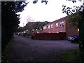
1

Strouden, Bishop of Winchester School
Comprehensive school, with its entrance from Mallard Road; seen here from Image http://www.tbows.co.uk/
Image: © Mike Faherty
Taken: 21 Jun 2009
0.03 miles
2
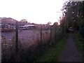
Strouden: footpath K48 alongside the Bishop of Winchester Academy
Looking along a public footpath which is the historic route of what is now Broad Avenue at the southern end and Castle Gate Close at the northwest end - this referring to a time before these suburbs of the town were built.
Here, we see it as it passes the main buildings of the Bishop of Winchester Academy, a popular secondary school, on the left.
See Image for the next view on the path ahead, and Image for the view behind us from roughly here - each with links to further pictures along the route.
Image: © Chris Downer
Taken: 5 Oct 2016
0.07 miles
3
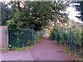
Strouden: footpath K48 passes the rear of Castlemore Retail Park
Looking along a public footpath which is the historic route of what is now Broad Avenue at the southern end and Castle Gate Close at the northwest end - this referring to a time before these suburbs of the town were built.
Here, we see it alongside the fences of the Castlemore Retail Park (right, see Image) and the Bishop of Winchester Academy (left).
See Image for the next view along the path ahead, and Image for the view behind us from about here - each with links to further pictures along the route.
Image: © Chris Downer
Taken: 5 Oct 2016
0.07 miles
4
Strouden: footpath K48 becomes a bit more rural
Looking along a public footpath which is the historic route of what is now Broad Avenue at the southern end and Castle Gate Close at the northwest end - this referring to a time before these suburbs of the town were built.
Behind us it is also a rear driveway but ahead it has a more path-like feel as it heads between the fences of the Castlemore Retail Park (left, see Image) and the Bishop of Winchester Academy (right).
See Image for the view behind us along the driveway, and Image for the next view on the path ahead - each with links to further pictures along the route.
Image: © Chris Downer
Taken: 5 Oct 2016
0.08 miles
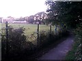
5
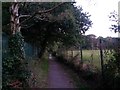
Strouden: silver birch on footpath K48
Looking along a public footpath which is the historic route of what is now Broad Avenue at the southern end and Castle Gate Close at the northwest end - this referring to a time before these suburbs of the town were built.
It is seen here having passed the Bishop of Winchester Academy, a popular secondary school, and now runs alongside the school's playing fields.
See Image for the view behind us from roughly here, and Image for the next view on the path ahead - each with links to further pictures along the route.
Image: © Chris Downer
Taken: 5 Oct 2016
0.08 miles
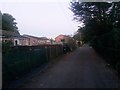
6
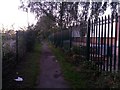
Strouden: footpath K48 behind 52a Mallard Road
A late evening view along the rear access to properties in Mallard Road - the block of flats at 52a immediately on our right and increasing even numbered bungalows beyond.
The driveway also forms public footpath K48, which is the historic route of what is now Broad Avenue at the southern end and Castle Gate Close at the northwest end - this referring to a time before these suburbs of the town were built.
See Image for the view towards us from ahead, and Image for the view behind us from about this spot, with links to further pictures along the route as it reaches more rural surroundings.
Image: © Chris Downer
Taken: 5 Oct 2016
0.09 miles
7
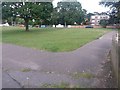
Strouden: footpath K07 from the play park
A photo taken from the same spot as Image (path K09 being off to the left).
This public footpath, numbered K07, is one of three which cross the green open space between the terrace of houses and the carriageway - see Image for a view from the other end.
Image: © Chris Downer
Taken: 25 Jun 2016
0.09 miles
8
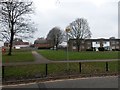
Strouden: footpath K07 from across Mallard Road
Looking across the carriageway of Mallard Road towards its odd-numbered houses across a grassed open space. The paved path is a public right of way, footpath K09, leading to path K06 which runs along the frontages.
See Image for another picture of the path from just across the road.
Image: © Chris Downer
Taken: 11 Feb 2017
0.09 miles
9
Strouden: footpath K48 passes the back of some bungalows
A late evening view along the rear access to properties in Mallard Road - even numbered bungalows 54-68 and, beyond, the block of flats 52a.
The driveway also forms public footpath K48, which is the historic route of what is now Broad Avenue at the southern end and Castle Gate Close at the northwest end - this referring to a time before these suburbs of the town were built.
Visible in the background is the gently curved roof of Castlemore Retail Park (the roof of the PC World premises just visible in Image).
See Image for the view from behind us at the end of the path, and Image for the next view on the path ahead, with links to further pictures along the route as it reaches more rural surroundings.
Image: © Chris Downer
Taken: 5 Oct 2016
0.10 miles
10
Strouden: footpath K48 and the Bishop of Winchester Academy
Looking along a public footpath which is the historic route of what is now Broad Avenue at the southern end and Castle Gate Close at the northwest end - this referring to a time before these suburbs of the town were built.
Here, we look into the faint, low evening sun above the roof of the Bishop of Winchester Academy (a secondary school, left) and its playing fields.
See Image for the next view on the path ahead, and Image for the next view behind us - each with links to further pictures along the route.
Image: © Chris Downer
Taken: 5 Oct 2016
0.10 miles