IMAGES TAKEN NEAR TO
Cooper Dean Drive, BOURNEMOUTH, BH8 9LN
Introduction
This page details the photographs taken nearby to Cooper Dean Drive, BH8 9LN by members of the Geograph project.
The Geograph project started in 2005 with the aim of publishing, organising and preserving representative images for every square kilometre of Great Britain, Ireland and the Isle of Man.

There are currently over 7.5m images from over14,400 individuals and you can help contribute to the project by visiting https://www.geograph.org.uk
Image Map (Loading...)


Getting Data...Please wait
Leaflet Map data © OpenStreetMap
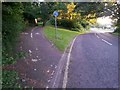
Images are licensed for reuse under creativecommons.org/licenses/by-sa/2.0
Notes
- Clicking on the map will re-center to the selected point.
- The higher the marker number, the further away the image location is from the centre of the postcode.
Image Listing (49 Images Found)
Images are licensed for reuse under creativecommons.org/licenses/by-sa/2.0
Image
Details
Distance
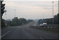
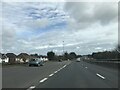
2
A338 Wessex Way, Exit Sliproad at the Cooper Dean Roundabout
Image: © David Dixon
Taken: 27 May 2016
0.05 miles
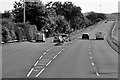
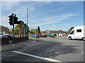
3
Bournemouth : Wessex Way A338
Wessex Way and Cooper Dean Drive heading off to the left.
Image: © Lewis Clarke
Taken: 27 Mar 2018
0.05 miles
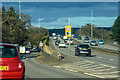
4
Bournemouth : Wessex Way A338
Joining Wessex Way from the roundabout.
Image: © Lewis Clarke
Taken: 27 Mar 2018
0.08 miles
7
Strouden: footpath K34 reaches Leydene Close
This public footpath from Craigmoor Close arrives at the head of the similar Leydene Close.
See Image for the view towards us from the end of the path, and Image for the next view behind us, with links to further pictures along both mentioned routes.
Image: © Chris Downer
Taken: 13 Jul 2016
0.12 miles
8
Strouden: footpath K34 from Leydene Close
This public footpath proceeds from the dead end of Leydene Close to the dead end of the similar Craigmoor Close. Behind the bungalow to the left we see the top of Image, to which an offshoot path also connects from midway along.
See Image for the view towards us from along the path, and links to further photos on the routes to Craigmoor Close and the church.
Image: © Chris Downer
Taken: 13 Jul 2016
0.12 miles
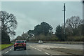
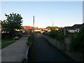
9
Queen?s Park: footpath K43 from Cooper Dean Drive
We look up the shared foot/cycle path, alongside the main A338 and along the edge of Queen's Park, from its eastern end.
Public footpath K43 is the first 26 metres, which brings it up to roughly level with the tree. The only reason I can think for this, is that the continuing path beyond is officially part of Queen's Park and therefore public anyway. There are public rights of way in other parts of the borough which stop when they reach public parks and open spaces.
See Image for a view from further up the path, with details of another short right of way which comes down the far side of the grass triangle.
An intervening view, towards us from the tree, is here: Image
Image: © Chris Downer
Taken: 13 Jul 2016
0.12 miles
10
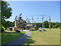
Littledown Park, Altitude
"High Ropes Adventure"; participants must wear hard hats, and are attached to a wire, in case of mishap. Cost of the full package of activities: £20. http://www.bhlive.co.uk/altitude-high-ropes-adventure/times-prices-and-tickets/
Image: © Mike Faherty
Taken: 6 Jul 2013
0.13 miles