IMAGES TAKEN NEAR TO
Bushey Road, BOURNEMOUTH, BH8 9HR
Introduction
This page details the photographs taken nearby to Bushey Road, BH8 9HR by members of the Geograph project.
The Geograph project started in 2005 with the aim of publishing, organising and preserving representative images for every square kilometre of Great Britain, Ireland and the Isle of Man.

There are currently over 7.5m images from over14,400 individuals and you can help contribute to the project by visiting https://www.geograph.org.uk
Image Map
Images are licensed for reuse under creativecommons.org/licenses/by-sa/2.0
Notes
- Clicking on the map will re-center to the selected point.
- The higher the marker number, the further away the image location is from the centre of the postcode.
Image Listing (74 Images Found)
Images are licensed for reuse under creativecommons.org/licenses/by-sa/2.0
Image
Details
Distance
1

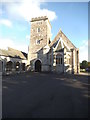
Crematorium and North Cemetery
This is situated on Strouden Avenue, North Bournemouth.
Image: © Stuart Buchan
Taken: 28 May 2006
0.03 miles
2
Bournemouth North Cemetery
Most of the gravestones in this section date from the 1940s. The cemetery has been Natural Death regional winner for several years.http://www.naturaldeath.org.uk/awards.html
Image: © Mike Faherty
Taken: 3 Mar 2009
0.05 miles
3
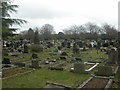
North Cemetery
The view in Bournemouth North Cemetery.
Image: © Gordon Griffiths
Taken: 26 Oct 2016
0.05 miles
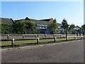
4
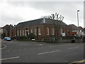
Charminster Library
Library at the junction of Charminster Road & Strouden Avenue, built 1932. For services offered, see http://www.bournemouth.gov.uk/Residents/Libraries/Info/charminster2.asp
Image: © Mike Faherty
Taken: 3 Mar 2009
0.07 miles
5
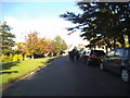
Charminster, Strouden Avenue
1930s houses close to Charminster Library Image
Image: © Mike Faherty
Taken: 3 Mar 2009
0.09 miles
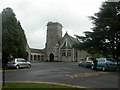
6
Crematorium Chapel
The view in Bournemouth North Cemetery of the chapel.
Image: © Gordon Griffiths
Taken: 26 Oct 2016
0.11 miles
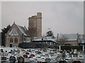
7
Bournemouth North Cemetery, chapel
Chapel & attached crematorium, consecrated 1931. For services offered, see http://www.bournemouth.gov.uk/Residents/births/Deaths/opening_times.asp
Image: © Mike Faherty
Taken: 3 Mar 2009
0.12 miles
9
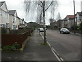
Charminster: Queen?s Park Infant School
Looking rather elderly, especially since its neighbour, Image, has recently been rebuilt.
Image: © Chris Downer
Taken: 22 Jun 2008
0.12 miles
10
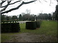
Bournemouth North Cemetery, war graves.
Situated to the South of the cemetery, and surrounded by a rectangle of yew hedging, this enclosure contains a war memorial, 75 gravestones & a stone plaque recording the names of 32 further war dead who were cremated; all from WW2.http://www.ww1cemeteries.com/british_cemeteries_memorials_ext/bournemouth_north_cem.htm
Image: © Mike Faherty
Taken: 3 Mar 2009
0.13 miles