IMAGES TAKEN NEAR TO
St. Georges Close, BOURNEMOUTH, BH8 9DS
Introduction
This page details the photographs taken nearby to St. Georges Close, BH8 9DS by members of the Geograph project.
The Geograph project started in 2005 with the aim of publishing, organising and preserving representative images for every square kilometre of Great Britain, Ireland and the Isle of Man.

There are currently over 7.5m images from over14,400 individuals and you can help contribute to the project by visiting https://www.geograph.org.uk
Image Map
Images are licensed for reuse under creativecommons.org/licenses/by-sa/2.0
Notes
- Clicking on the map will re-center to the selected point.
- The higher the marker number, the further away the image location is from the centre of the postcode.
Image Listing (35 Images Found)
Images are licensed for reuse under creativecommons.org/licenses/by-sa/2.0
Image
Details
Distance
1
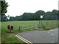
Queens Park, Bournemouth
This is the west end car park area of Queens Park.
Image: © Stuart Buchan
Taken: 1 Aug 2005
0.04 miles
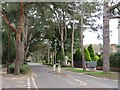
2
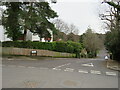
Queen's Park Avenue, Bournemouth
Queen's Park Avenue is a residential road in the suburbs of Bournemouth.
Image: © Malc McDonald
Taken: 7 Feb 2022
0.14 miles
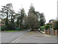
3
Queen's Park Avenue, Bournemouth
Houses were built along the north side of this section of Queen's Park Avenue in the 1920s by a local builder who as a town councillor arranged illegally for the land, part of Queen's Park, to be sold to him for development. The houses have among the finest views in Bournemouth.
Image: © Stephen James
Taken: 16 Mar 2004
0.14 miles
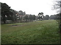
4
Queen's Park, Bournemouth
A view taken in Queen's Park, in the suburbs of Bournemouth. This section of the park is used for golf.
Image: © Malc McDonald
Taken: 7 Feb 2022
0.15 miles
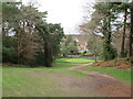
5
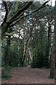
Rope swing
In a wooded corner of Queen's Park.
Image: © David Lally
Taken: 11 Apr 2011
0.16 miles
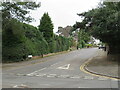
6
Queen's Park Avenue, Bournemouth
Queen's Park Avenue is a tree-lined road in the suburbs of Bournemouth.
Image: © Malc McDonald
Taken: 7 Feb 2022
0.16 miles
7
Howard Road, Queen's Park, Bournemouth
Howard Road is a residential road in the Queen's Park area of Bournemouth.
Image: © Malc McDonald
Taken: 7 Feb 2022
0.16 miles
8
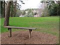
Bench in Queen's Park, Bournemouth
A bench seat in Queen's Park, in the suburbs of Bournemouth.
Image: © Malc McDonald
Taken: 7 Feb 2022
0.17 miles
9
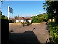
Charminster: footpath K03 reaches Burnham Drive
This public footpath from Howard Road emerges onto Burnham Drive at its top end. The road in each direction here goes round in a circle before dropping down to Queen's Park Avenue, so this is effectively a dead end, with the bungalow in front of us one of those on the inside of the circle.
See Image for a view towards us from across the road, and Image for the view behind us, and links to further photos along the path.
Image: © Chris Downer
Taken: 13 Jul 2016
0.17 miles
10
Maurice Road, Queen's Park, Bournemouth
Maurice Road is a residential road in the Queen's Park area of Bournemouth.
Image: © Malc McDonald
Taken: 7 Feb 2022
0.18 miles