IMAGES TAKEN NEAR TO
Lowther Road, BOURNEMOUTH, BH8 8NN
Introduction
This page details the photographs taken nearby to Lowther Road, BH8 8NN by members of the Geograph project.
The Geograph project started in 2005 with the aim of publishing, organising and preserving representative images for every square kilometre of Great Britain, Ireland and the Isle of Man.

There are currently over 7.5m images from over14,400 individuals and you can help contribute to the project by visiting https://www.geograph.org.uk
Image Map
Images are licensed for reuse under creativecommons.org/licenses/by-sa/2.0
Notes
- Clicking on the map will re-center to the selected point.
- The higher the marker number, the further away the image location is from the centre of the postcode.
Image Listing (73 Images Found)
Images are licensed for reuse under creativecommons.org/licenses/by-sa/2.0
Image
Details
Distance
1
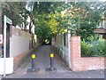
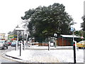
Malmesbury Park: footpath C16 to Milton Road
Looking along this suburban public footpath, just under 100m in length, from the Lowther Road end.
See Image for the next view along the path.
Image: © Chris Downer
Taken: 3 Jul 2016
0.06 miles
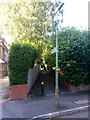
2
Malmesbury Park: lamppost on footpath C16
One of two lampposts on this public footpath between Lowther (ahead) and Milton Roads.
See Image for a picture looking towards us from the far end, and Image] for the next view along the path behind us.
Image: © Chris Downer
Taken: 3 Jul 2016
0.07 miles
3
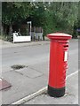
Charminster: postbox № BH8 133, Lowther Road
Opposite can be seen a footpath to Milton Road.
Image: © Chris Downer
Taken: 10 Jul 2008
0.07 miles
4
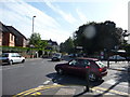
Bournemouth : Charminster - Charminster Road
Road junction with Heron Court Road.
Image: © Lewis Clarke
Taken: 20 May 2009
0.07 miles
5
Charminster: junction of Heron Court, Iddesleigh and Charminster Roads
Heron Court Road, nearest us, and Iddesleigh Road to the right, both come out on Charminster Road, here by the northern end of the cemetery (which is behind the large tree).
Two days after heavy snow earlier in the week had all thawed, this fresh lot fell from the north this morning, despite the fact that the day started rainy, with large puddles all around.
By nightfall, the main carriageways of all roads were clear of snow and ice, so this was a very heavy fall considering that it started and had almost disappeared on the same day.
Image: © Chris Downer
Taken: 6 Feb 2009
0.07 miles
6
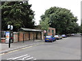
Substation and road
Street view including a sub station brick building set back in to the cemetery, public British Telecom call box and a shelter.
Image: © Mat Tuck
Taken: 26 Jul 2013
0.07 miles
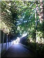
7
Malmesbury Park: footpath C16 to Lowther Road
Looking along this dead straight public footpath, just under 100m in length, from the Milton Road end.
See Image for the next view along the path.
Image: © Chris Downer
Taken: 3 Jul 2016
0.07 miles
8
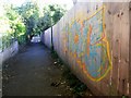
Malmesbury Park: graffiti on footpath C16
A colourful but mindless adornment to this public footpath between Milton and Lowther Roads.
See Image] for the view towards us from the end, and Image for the next photo along the path behind us.
Image: © Chris Downer
Taken: 3 Jul 2016
0.08 miles
9
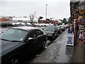
Bournemouth : Charminster Road
The pavement along Charminster Road and car dealership opposite.
Image: © Lewis Clarke
Taken: 6 Feb 2009
0.08 miles
10

Bournemouth : Charminster - Charminster Road
Image: © Lewis Clarke
Taken: 20 May 2009
0.09 miles