IMAGES TAKEN NEAR TO
Milton Road, BOURNEMOUTH, BH8 8FW
Introduction
This page details the photographs taken nearby to Milton Road, BH8 8FW by members of the Geograph project.
The Geograph project started in 2005 with the aim of publishing, organising and preserving representative images for every square kilometre of Great Britain, Ireland and the Isle of Man.

There are currently over 7.5m images from over14,400 individuals and you can help contribute to the project by visiting https://www.geograph.org.uk
Image Map
Images are licensed for reuse under creativecommons.org/licenses/by-sa/2.0
Notes
- Clicking on the map will re-center to the selected point.
- The higher the marker number, the further away the image location is from the centre of the postcode.
Image Listing (40 Images Found)
Images are licensed for reuse under creativecommons.org/licenses/by-sa/2.0
Image
Details
Distance
2
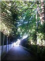
Malmesbury Park: footpath C16 to Lowther Road
Looking along this dead straight public footpath, just under 100m in length, from the Milton Road end.
See Image for the next view along the path.
Image: © Chris Downer
Taken: 3 Jul 2016
0.11 miles
3
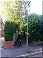
Malmesbury Park: lamppost on footpath C16
One of two lampposts on this public footpath between Lowther (ahead) and Milton Roads.
See Image for a picture looking towards us from the far end, and Image] for the next view along the path behind us.
Image: © Chris Downer
Taken: 3 Jul 2016
0.11 miles
4
Malmesbury Park: footpath C16 to Milton Road
Looking along this suburban public footpath, just under 100m in length, from the Lowther Road end.
See Image for the next view along the path.
Image: © Chris Downer
Taken: 3 Jul 2016
0.11 miles
5
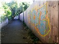
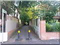
Malmesbury Park: graffiti on footpath C16
A colourful but mindless adornment to this public footpath between Milton and Lowther Roads.
See Image] for the view towards us from the end, and Image for the next photo along the path behind us.
Image: © Chris Downer
Taken: 3 Jul 2016
0.12 miles
6
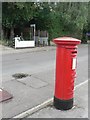
Malmesbury Park: postbox № BH8 151, Portchester Road
An Edward VII-reign box, with the ambulance station in the background.
Image: © Chris Downer
Taken: 10 Jul 2008
0.12 miles
7
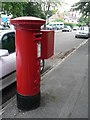
Charminster: postbox № BH8 133, Lowther Road
Opposite can be seen a footpath to Milton Road.
Image: © Chris Downer
Taken: 10 Jul 2008
0.12 miles
8

Bournemouth: ambulance station garages
A view along the rear driveway of Dorset Ambulance NHS Trust headquarters, at a line of ambulance bonnets.
Image: © Chris Downer
Taken: 10 Jul 2008
0.13 miles
9

Malmesbury Park: the Brunswick smoking area
The Image has produced a novel solution to the ban on smoking in enclosed public spaces, which came into force in July 2007.
This courtyard has been built, which looks for all the world like it is an interior space, complete with fire and hearth, and large screen tv. In fact, the 'ceiling' is in fact merely a canopy and we are viewing from a table open to the elements.
Image: © Chris Downer
Taken: 25 Aug 2012
0.14 miles
10

Malmesbury Park: The Brunswick and St. Leonard?s Road
Image is dated 1883 above the right-hand window, and contrasts with the majority of the roads around here (see Image). It is on the corner of Malmesbury Park Road and St. Leonard’s Road, from which latter this picture was taken.
Image: © Chris Downer
Taken: 1 Jan 2008
0.14 miles