IMAGES TAKEN NEAR TO
Benellen Avenue, BOURNEMOUTH, BH4 9LT
Introduction
This page details the photographs taken nearby to Benellen Avenue, BH4 9LT by members of the Geograph project.
The Geograph project started in 2005 with the aim of publishing, organising and preserving representative images for every square kilometre of Great Britain, Ireland and the Isle of Man.

There are currently over 7.5m images from over14,400 individuals and you can help contribute to the project by visiting https://www.geograph.org.uk
Image Map
Images are licensed for reuse under creativecommons.org/licenses/by-sa/2.0
Notes
- Clicking on the map will re-center to the selected point.
- The higher the marker number, the further away the image location is from the centre of the postcode.
Image Listing (128 Images Found)
Images are licensed for reuse under creativecommons.org/licenses/by-sa/2.0
Image
Details
Distance
1
Benellen Rd
Benellen Road is a short residential street with substantial individual houses, many with private swimming pools. It runs between Glenferness Avenue and Benellen Avenue just north of the Bourne river.
Image: © Nigel Mykura
Taken: 8 May 2012
0.05 miles
2
Stone built house
A stone built house on the junction of Branksome Wood Road and Benellen Avenue.
Image: © Mat Tuck
Taken: 23 Jul 2013
0.06 miles
3
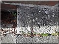
Bournemouth: rivet bench mark on Prince of Wales Road steps
An Ordnance Survey benchmark, in the form of a rivet, is set into the small patch of concrete on the steps shown in Image
An etched arrowhead helpfully points to it.
Image: © Chris Downer
Taken: 27 Jan 2019
0.08 miles
4
Bournemouth: steps cut off the Prince of Wales Road corner
Prince of Wales Road, on whose kerbstones we are standing, arrives on Branksome Wood Road at a very acute angle. The pedestrian can save a few yards' walk by taking the steps which cut the corner off slightly.
Image: © Chris Downer
Taken: 27 Jan 2019
0.08 miles
5
Prince of Wales Road, Bournemouth
Prince of Wales Road is a one-way road which crosses the Bourne Valley in the suburbs of Bournemouth.
Image: © Malc McDonald
Taken: 25 Aug 2021
0.09 miles
6
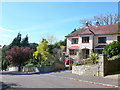
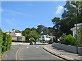
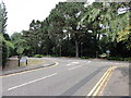
Benellen Avenue, Bournemouth
Seen from its junction with Leven Avenue. A very arboreal part of Bournemouth.
Image: © Derek Harper
Taken: 12 Oct 2009
0.09 miles
7
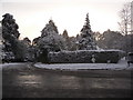
Talbot Woods: Benellen Avenue and Walsford Road come out on Leven Avenue
Looking across Leven Avenue the day after Bournemouth's heaviest snow for 17 years fell overnight. The two side roads have come up quite steep hills and are probably ungritted so they will have been awkward to negotiate today.
Image: © Chris Downer
Taken: 2 Dec 2010
0.09 miles
8
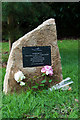
Pilot Officer C H Hight - a tribute: the memorial of Portland stone (4)
This Portland stone memorial with its plaque commemorates the sacrifice of 22 year old RAF Pilot Officer Cecil Henry Hight from New Zealand, killed in a dogfight over Bournemouth on 15 August 1940 during the Battle of Britain. It marks the spot on the corner of Leven Avenue and Walsford Road where his Spitfire crashed, and just 50 yards from the garden of 'Hambledon' where his body was found. The memorial was unveiled by Bournemouth Mayor John Adams, and local MP Conor Burns on 15 August 2015, on the 75th anniversary of P/O Hight's death.
Image
Image: © Mike Searle
Taken: 23 Sep 2015
0.09 miles
9
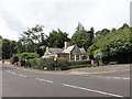
Bournemouth: Pilot Cecil Hight memorial tree
Situated on the acute turning of Benellen Avenue and Walsford Road onto Leven Avenue, this tree was planted in August 2015 to commemorate New Zealander Cecil Hight, a 22-year-old Pilot Officer who was killed during the Battle of Britain on this spot where his Spitfire crashed on 15 August 1940.
His name also lives on in the Bournemouth suburb of West Howe, whose roads are named after wartime servicemen with local connection: the road names such as Cunningham Crescent, Moore Avenue and Draper Road are recognisably surnames, and his is the one name prefixed with occupational title - Pilot Hight Road. See Image
Image: © Chris Downer
Taken: 17 Apr 2018
0.09 miles
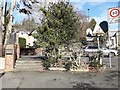
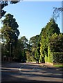
10
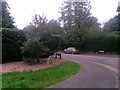
Road junction of Benellen Ave and Walford Road meeting Leven Ave
All three roads meet at this point, with a foot path trail in to Meyrick Park.
Image: © Mat Tuck
Taken: 23 Jul 2013
0.10 miles