IMAGES TAKEN NEAR TO
Branksome Hill Road, BOURNEMOUTH, BH4 9LE
Introduction
This page details the photographs taken nearby to Branksome Hill Road, BH4 9LE by members of the Geograph project.
The Geograph project started in 2005 with the aim of publishing, organising and preserving representative images for every square kilometre of Great Britain, Ireland and the Isle of Man.

There are currently over 7.5m images from over14,400 individuals and you can help contribute to the project by visiting https://www.geograph.org.uk
Image Map
Images are licensed for reuse under creativecommons.org/licenses/by-sa/2.0
Notes
- Clicking on the map will re-center to the selected point.
- The higher the marker number, the further away the image location is from the centre of the postcode.
Image Listing (120 Images Found)
Images are licensed for reuse under creativecommons.org/licenses/by-sa/2.0
Image
Details
Distance
1
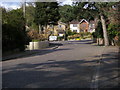
Dorset Road
Dorset Road heading up to Branksome Hill Road
Image: © Shaun Ferguson
Taken: 14 Apr 2008
0.06 miles
2
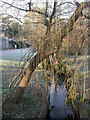
Poole Upper Gardens, Bourne Stream
As seen from roadbridge on Brunstead Road Image, which forms the boundary between Bournemouth & Poole. For information about the gardens, see http://boroughofpoole.com/facilities/ref:F465e9bc752c16/
Image: © Mike Faherty
Taken: 9 Jan 2009
0.10 miles
3
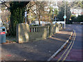
Poole, Brunstead Road bridge
1930s bridge over the Bourne Stream; to the left, Upper Gardens in Poole, Image, on the other side of the bridge, out of sight, Upper Gardens in Bournemouth Image, at a different time of year.
Image: © Mike Faherty
Taken: 9 Jan 2009
0.10 miles

6
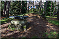
Talbot Heath School for Girls, Bournemouth - WWII Air Raid Shelter (1)
-
Air Raid Shelter: DoB ID: e42058
The visible remains above ground of one of four deep underground air raid shelters built during 1939 for the pupils and staff of the school. This one was opened to the public specially for a Heritage Open Day event. Used as a storeroom after the end of the war, this is the only accessible shelter, the others remain buried and unexcavated. This air raid shelter was refurbished and made habitable again in 2011, and is in use today as a 'Living History' classroom. Together, all four shelters could accommodate up to 125 pupils and staff at any one time. The School's archives show that the shelters were used extensively day and night throughout the war, and particularly during the most intensive period of 1939 - 1940.
In the foreground protruding above the protective earth bank can be seen the concrete surround of the emergency escape hatch. The basic construction of the shelter consisted of sheets of corrugated iron bolted together supported by a framework of curved steel girders. After being given a concrete roof, the whole structure was then banked over with a covering of earth.
Image
Image: © Mike Searle
Taken: 9 Sep 2017
0.11 miles
7
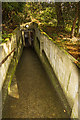
Talbot Heath School for Girls, Bournemouth - WWII Air Raid Shelter (2)
-
Air Raid Shelter: DoB ID: e42058
The entrance passageway is a steeply sloping pathway protected by concrete blast walls on either side.
Image
Image: © Mike Searle
Taken: 9 Sep 2017
0.11 miles
8
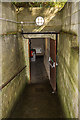
Talbot Heath School for Girls, Bournemouth - WWII Air Raid Shelter (3)
-
Air Raid Shelter: DoB ID: e42058
The shelter's entrance doorway and vestibule that requires a sharp right turn at the end to enter, with no idea at this stage what lies beyond.
Image
Image: © Mike Searle
Taken: 9 Sep 2017
0.11 miles
9
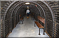
Talbot Heath School for Girls, Bournemouth - WWII Air Raid Shelter (4)
-
Air Raid Shelter: DoB ID: e42058
The view of the interior from the entrance vestibule. Nothing prepares you for the sight of the interior of the shelter for the first time - its size is quite astonishing. For those interested in statistics, the interior is 20 metres long, by 2 metres wide, and 2 metres high. The benches that lined the sides (most have been removed to accommodate today's visitors), also doubled up as temporary beds by placing them together. The School's archives record that they were thus used during the intense period of enemy bombing of 1939 - 1940, when around 30 pupils and staff would have sheltered here.
Image
Image: © Mike Searle
Taken: 9 Sep 2017
0.11 miles
10
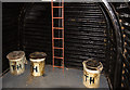
Talbot Heath School for Girls, Bournemouth - WWII Air Raid Shelter (5)
-
Air Raid Shelter: DoB ID: e42058
The chemical toilet facility at the south end of the shelter. 'Curtains? Don't you know there's a war on?' The ladder serves the emergency escape hatch.
Image
Image: © Mike Searle
Taken: 9 Sep 2017
0.11 miles