IMAGES TAKEN NEAR TO
Surrey Road South, BOURNEMOUTH, BH4 9BL
Introduction
This page details the photographs taken nearby to Surrey Road South, BH4 9BL by members of the Geograph project.
The Geograph project started in 2005 with the aim of publishing, organising and preserving representative images for every square kilometre of Great Britain, Ireland and the Isle of Man.

There are currently over 7.5m images from over14,400 individuals and you can help contribute to the project by visiting https://www.geograph.org.uk
Image Map
Images are licensed for reuse under creativecommons.org/licenses/by-sa/2.0
Notes
- Clicking on the map will re-center to the selected point.
- The higher the marker number, the further away the image location is from the centre of the postcode.
Image Listing (147 Images Found)
Images are licensed for reuse under creativecommons.org/licenses/by-sa/2.0
Image
Details
Distance
2
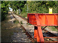
End of the line
The bufferstops at the eastern end of Bournemouth Traction & Rolling Stock Maintenance Depot. The running lines to/from the old Bournemouth West station were just to the left of this remaining solitary siding, now used as a headshunt from the carriage washing machine.
Image: © Peter Kazmierczak
Taken: 3 Oct 2009
0.03 miles
3

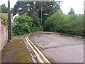
Westbourne: steps on footpath A12
The last part of this public footpath, from Surrey Road South, comprises a short flight of steps which emerge at the end of Wharfdale Road - see Image
See Image for the path behind us.
Image: © Chris Downer
Taken: 13 Jun 2016
0.04 miles
4
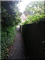
Westbourne: footpath A12 approaches Surrey Road South
A house in Surrey Road South can just be glimpsed as we look down this narrow public footpath from Wharfdale Road.
See
Image for the steps at the other end of the path (behind us), and
Image for the view up to here from the roadside ahead.
Image: © Chris Downer
Taken: 13 Jun 2016
0.04 miles
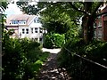
5
Westbourne: footpath A12 from Surrey Road South
Looking across the carriageway of Surrey Road South, towards the narrow public footpath which leads up to Wharfdale Road.
See the following other pictures:
Image looking this way from along the path
Image the steps at the far end of the path
Image a view of the path from the Wharfdale Road end
Image: © Chris Downer
Taken: 13 Jun 2016
0.04 miles
6
Westbourne: the end of Wharfdale Road and the start of footpath A12
Wharfdale Road ends straightforwardly and abruptly, without much space to turn a vehicle. The pedestrian route continues down some steps by the lamppost, a public footpath leading down to Surrey Road South.
See Image for a picture of the steps.
Image: © Chris Downer
Taken: 13 Jun 2016
0.04 miles
7
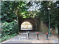
Railway bridge
Railway bridge with a footpath and cycle lane passing under it. The railway passing over is a siding from the Bournemouth Railway Depot.
Image: © Mat Tuck
Taken: 23 Jul 2013
0.05 miles
8
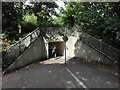
Subway passing under the Wessex Way
Subway and cycle path passing under the Wessex Way.
Image: © Mat Tuck
Taken: 23 Jul 2013
0.06 miles
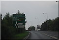
10
Westbourne: footpath A08 reaches Pine Tree Glen
This public footpath from Poole Road reaches its destination, the dead end of Pine Tree Glen.
See Image for the view up the path from ahead, and Image for the view up the path behind us.
Image: © Chris Downer
Taken: 14 Jul 2016
0.08 miles